You are here: Home > Network List > IU - Global Seismograph Network (GSN - IRIS/USGS) Stations List
> Station MAKZ Makanchi, Kazakhstan > Earthquake Result Viewer
MAKZ Makanchi, Kazakhstan - Earthquake Result Viewer
| Earthquake location: |
Negros, Philippines |
| Earthquake latitude/longitude: |
10.0/123.2 |
| Earthquake time(UTC): |
2012/02/06 (037) 03:49:12 GMT |
| Earthquake Depth: |
11 km |
| Earthquake Magnitude: |
6.3 MB, 6.6 MS, 6.7 MW, 6.7 MW |
| Earthquake Catalog/Contributor: |
WHDF/NEIC |
|
| Network: |
IU Global Seismograph Network (GSN - IRIS/USGS) |
| Station: |
MAKZ Makanchi, Kazakhstan |
| Lat/Lon: |
46.81 N/81.98 E |
| Elevation: |
600 m |
|
| Distance: |
50.6 deg |
| Az: |
324.159 deg |
| Baz: |
122.895 deg |
| Ray Param: |
0.06791966 |
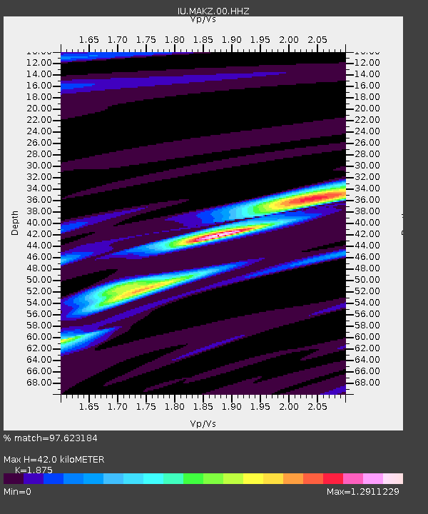
| Estimated Moho Depth: |
42.0 km |
| Estimated Crust Vp/Vs: |
1.88 |
| Assumed Crust Vp: |
6.571 km/s |
| Estimated Crust Vs: |
3.504 km/s |
| Estimated Crust Poisson's Ratio: |
0.30 |
|
| Radial Match: |
97.623184 % |
| Radial Bump: |
220 |
| Transverse Match: |
84.87805 % |
| Transverse Bump: |
400 |
| SOD ConfigId: |
558545 |
| Insert Time: |
2013-09-19 11:17:22.398 +0000 |
| GWidth: |
2.5 |
| Max Bumps: |
400 |
| Tol: |
0.001 |
|

Signal To Noise
| Channel | StoN | STA | LTA |
| IU:MAKZ:00:HHZ:20120206T03:57:40.557994Z | 34.499462 | 3.1200634E-6 | 9.0438036E-8 |
| IU:MAKZ:00:HH1:20120206T03:57:40.557994Z | 13.961401 | 7.092278E-7 | 5.0799187E-8 |
| IU:MAKZ:00:HH2:20120206T03:57:40.557994Z | 18.03507 | 1.4327833E-6 | 7.9444284E-8 |
| Arrivals |
| Ps | 5.9 SECOND |
| PpPs | 17 SECOND |
| PsPs/PpSs | 23 SECOND |


