You are here: Home > Network List > CN - Canadian National Seismograph Network Stations List
> Station LLLB LILLOOET, BC, CANADA ADA > Earthquake Result Viewer
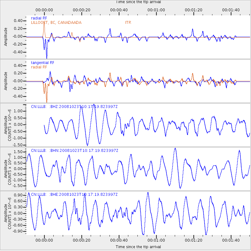
LLLB LILLOOET, BC, CANADA ADA - Earthquake Result Viewer
*The percent match for this event was below the threshold and hence no stack was calculated.
| Earthquake location: |
Admiralty Islands Region, P.N.G. |
| Earthquake latitude/longitude: |
-2.6/145.6 |
| Earthquake time(UTC): |
2008/10/23 (297) 10:04:35 GMT |
| Earthquake Depth: |
10 km |
| Earthquake Magnitude: |
6.0 MB, 6.3 MS, 6.3 MW, 6.3 MW |
| Earthquake Catalog/Contributor: |
WHDF/NEIC |
|
| Network: |
CN Canadian National Seismograph Network |
| Station: |
LLLB LILLOOET, BC, CANADA ADA |
| Lat/Lon: |
50.61 N/121.88 W |
| Elevation: |
700 m |
|
| Distance: |
93.6 deg |
| Az: |
39.629 deg |
| Baz: |
270.292 deg |
| Ray Param: |
$rayparam |
*The percent match for this event was below the threshold and hence was not used in the summary stack. |
|
| Radial Match: |
66.151245 % |
| Radial Bump: |
355 |
| Transverse Match: |
58.755913 % |
| Transverse Bump: |
400 |
| SOD ConfigId: |
2556 |
| Insert Time: |
2010-02-27 06:41:38.341 +0000 |
| GWidth: |
2.5 |
| Max Bumps: |
400 |
| Tol: |
0.001 |
|
Signal To Noise
| Channel | StoN | STA | LTA |
| CN:LLLB: :BHN:20081023T10:17:19.823997Z | 0.6621407 | 4.994152E-7 | 7.542433E-7 |
| CN:LLLB: :BHE:20081023T10:17:19.823997Z | 0.50739443 | 2.475811E-7 | 4.87946E-7 |
| CN:LLLB: :BHZ:20081023T10:17:19.823997Z | 1.4122233 | 8.5787394E-7 | 6.0746333E-7 |
| Arrivals |
| Ps | |
| PpPs | |
| PsPs/PpSs | |


