You are here: Home > Network List > IU - Global Seismograph Network (GSN - IRIS/USGS) Stations List
> Station POHA Pohakuloa, Hawaii, USA > Earthquake Result Viewer
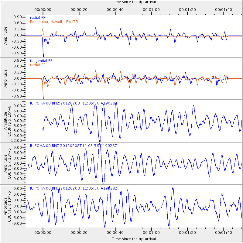
POHA Pohakuloa, Hawaii, USA - Earthquake Result Viewer
*The percent match for this event was below the threshold and hence no stack was calculated.
| Earthquake location: |
Near Coast Of Ecuador |
| Earthquake latitude/longitude: |
0.7/-79.3 |
| Earthquake time(UTC): |
2012/02/08 (039) 10:54:42 GMT |
| Earthquake Depth: |
64 km |
| Earthquake Magnitude: |
5.6 MB, 5.6 ML |
| Earthquake Catalog/Contributor: |
NEIC PDE/NEIC PDE-M |
|
| Network: |
IU Global Seismograph Network (GSN - IRIS/USGS) |
| Station: |
POHA Pohakuloa, Hawaii, USA |
| Lat/Lon: |
19.76 N/155.53 W |
| Elevation: |
1990 m |
|
| Distance: |
76.9 deg |
| Az: |
290.024 deg |
| Baz: |
94.062 deg |
| Ray Param: |
$rayparam |
*The percent match for this event was below the threshold and hence was not used in the summary stack. |
|
| Radial Match: |
53.288883 % |
| Radial Bump: |
379 |
| Transverse Match: |
56.8342 % |
| Transverse Bump: |
339 |
| SOD ConfigId: |
558545 |
| Insert Time: |
2013-09-19 11:25:04.714 +0000 |
| GWidth: |
2.5 |
| Max Bumps: |
400 |
| Tol: |
0.001 |
|
Signal To Noise
| Channel | StoN | STA | LTA |
| IU:POHA:00:BHZ:20120208T11:05:56.419028Z | 1.1742038 | 3.332079E-6 | 2.8377349E-6 |
| IU:POHA:00:BH1:20120208T11:05:56.419028Z | 1.2115407 | 5.0988897E-6 | 4.2085994E-6 |
| IU:POHA:00:BH2:20120208T11:05:56.419028Z | 2.234608 | 8.080531E-6 | 3.6160843E-6 |
| Arrivals |
| Ps | |
| PpPs | |
| PsPs/PpSs | |


