You are here: Home > Network List > IU - Global Seismograph Network (GSN - IRIS/USGS) Stations List
> Station RSSD Black Hills, South Dakota, USA > Earthquake Result Viewer
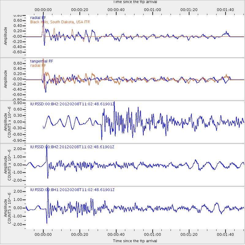
RSSD Black Hills, South Dakota, USA - Earthquake Result Viewer
*The percent match for this event was below the threshold and hence no stack was calculated.
| Earthquake location: |
Near Coast Of Ecuador |
| Earthquake latitude/longitude: |
0.7/-79.3 |
| Earthquake time(UTC): |
2012/02/08 (039) 10:54:42 GMT |
| Earthquake Depth: |
64 km |
| Earthquake Magnitude: |
5.6 MB, 5.6 ML |
| Earthquake Catalog/Contributor: |
NEIC PDE/NEIC PDE-M |
|
| Network: |
IU Global Seismograph Network (GSN - IRIS/USGS) |
| Station: |
RSSD Black Hills, South Dakota, USA |
| Lat/Lon: |
44.12 N/104.04 W |
| Elevation: |
2090 m |
|
| Distance: |
48.6 deg |
| Az: |
336.259 deg |
| Baz: |
146.014 deg |
| Ray Param: |
$rayparam |
*The percent match for this event was below the threshold and hence was not used in the summary stack. |
|
| Radial Match: |
75.46446 % |
| Radial Bump: |
400 |
| Transverse Match: |
63.36539 % |
| Transverse Bump: |
400 |
| SOD ConfigId: |
558545 |
| Insert Time: |
2013-09-19 11:25:14.158 +0000 |
| GWidth: |
2.5 |
| Max Bumps: |
400 |
| Tol: |
0.001 |
|
Signal To Noise
| Channel | StoN | STA | LTA |
| IU:RSSD:00:BHZ:20120208T11:02:48.61901Z | 3.5222828 | 7.640345E-7 | 2.1691459E-7 |
| IU:RSSD:00:BH1:20120208T11:02:48.61901Z | 5.1149464 | 8.187339E-7 | 1.6006696E-7 |
| IU:RSSD:00:BH2:20120208T11:02:48.61901Z | 1.8791864 | 3.0222725E-7 | 1.6082878E-7 |
| Arrivals |
| Ps | |
| PpPs | |
| PsPs/PpSs | |


