You are here: Home > Network List > II - Global Seismograph Network (GSN - IRIS/IDA) Stations List
> Station WRAB Tennant Creek, NT, Australia > Earthquake Result Viewer
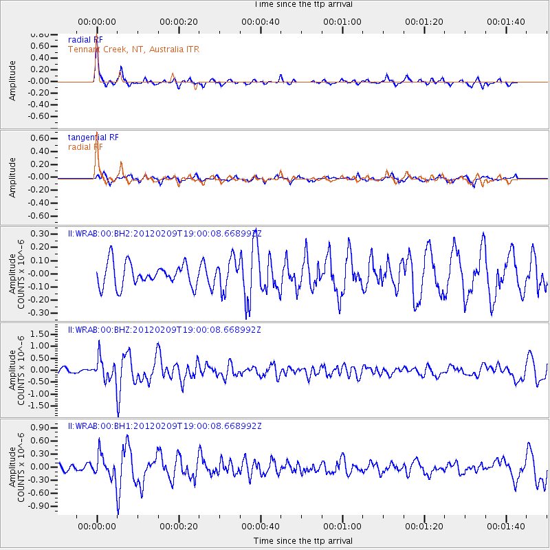
WRAB Tennant Creek, NT, Australia - Earthquake Result Viewer
*The percent match for this event was below the threshold and hence no stack was calculated.
| Earthquake location: |
Macquarie Island Region |
| Earthquake latitude/longitude: |
-58.3/157.8 |
| Earthquake time(UTC): |
2012/02/09 (040) 18:52:48 GMT |
| Earthquake Depth: |
10 km |
| Earthquake Magnitude: |
5.6 MB, 5.4 MS, 5.9 MW, 5.8 MW |
| Earthquake Catalog/Contributor: |
WHDF/NEIC |
|
| Network: |
II Global Seismograph Network (GSN - IRIS/IDA) |
| Station: |
WRAB Tennant Creek, NT, Australia |
| Lat/Lon: |
19.93 S/134.36 E |
| Elevation: |
366 m |
|
| Distance: |
42.0 deg |
| Az: |
325.921 deg |
| Baz: |
161.677 deg |
| Ray Param: |
$rayparam |
*The percent match for this event was below the threshold and hence was not used in the summary stack. |
|
| Radial Match: |
76.81574 % |
| Radial Bump: |
242 |
| Transverse Match: |
59.664116 % |
| Transverse Bump: |
336 |
| SOD ConfigId: |
558545 |
| Insert Time: |
2013-09-19 11:32:55.820 +0000 |
| GWidth: |
2.5 |
| Max Bumps: |
400 |
| Tol: |
0.001 |
|
Signal To Noise
| Channel | StoN | STA | LTA |
| II:WRAB:00:BHZ:20120209T19:00:08.668992Z | 3.4553282 | 4.7630044E-7 | 1.378452E-7 |
| II:WRAB:00:BH1:20120209T19:00:08.668992Z | 2.4147515 | 2.7472933E-7 | 1.1377126E-7 |
| II:WRAB:00:BH2:20120209T19:00:08.668992Z | 1.334629 | 1.147635E-7 | 8.5989065E-8 |
| Arrivals |
| Ps | |
| PpPs | |
| PsPs/PpSs | |


