You are here: Home > Network List > IU - Global Seismograph Network (GSN - IRIS/USGS) Stations List
> Station MAJO Matsushiro, Japan > Earthquake Result Viewer
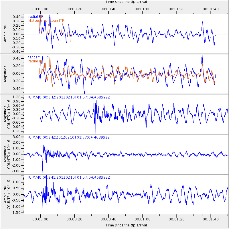
MAJO Matsushiro, Japan - Earthquake Result Viewer
*The percent match for this event was below the threshold and hence no stack was calculated.
| Earthquake location: |
Fiji Islands Region |
| Earthquake latitude/longitude: |
-18.0/-178.5 |
| Earthquake time(UTC): |
2012/02/10 (041) 01:47:34 GMT |
| Earthquake Depth: |
582 km |
| Earthquake Magnitude: |
6.0 MB, 5.9 MW, 6.0 MW |
| Earthquake Catalog/Contributor: |
WHDF/NEIC |
|
| Network: |
IU Global Seismograph Network (GSN - IRIS/USGS) |
| Station: |
MAJO Matsushiro, Japan |
| Lat/Lon: |
36.55 N/138.20 E |
| Elevation: |
405 m |
|
| Distance: |
67.9 deg |
| Az: |
323.446 deg |
| Baz: |
135.255 deg |
| Ray Param: |
$rayparam |
*The percent match for this event was below the threshold and hence was not used in the summary stack. |
|
| Radial Match: |
43.663795 % |
| Radial Bump: |
387 |
| Transverse Match: |
70.22107 % |
| Transverse Bump: |
400 |
| SOD ConfigId: |
558545 |
| Insert Time: |
2013-09-19 11:35:31.444 +0000 |
| GWidth: |
2.5 |
| Max Bumps: |
400 |
| Tol: |
0.001 |
|
Signal To Noise
| Channel | StoN | STA | LTA |
| IU:MAJO:00:BHZ:20120210T01:57:04.468992Z | 5.029255 | 8.2685574E-7 | 1.644092E-7 |
| IU:MAJO:00:BH1:20120210T01:57:04.468992Z | 1.2249253 | 4.3265928E-7 | 3.5321278E-7 |
| IU:MAJO:00:BH2:20120210T01:57:04.468992Z | 1.408206 | 3.9926428E-7 | 2.835269E-7 |
| Arrivals |
| Ps | |
| PpPs | |
| PsPs/PpSs | |


