You are here: Home > Network List > US - United States National Seismic Network Stations List
> Station LAO LASA Array, Montana, USA > Earthquake Result Viewer
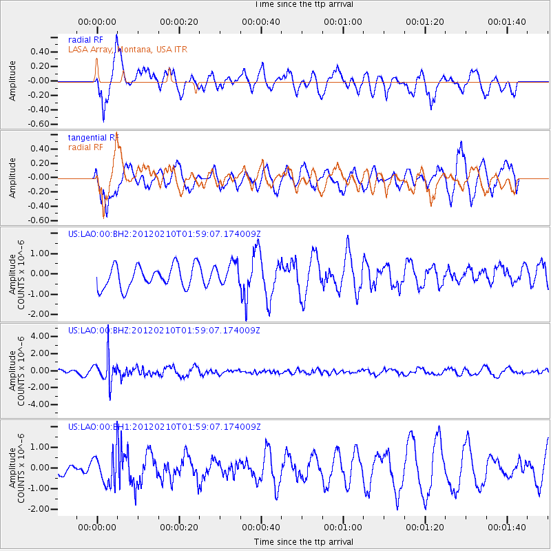
LAO LASA Array, Montana, USA - Earthquake Result Viewer
*The percent match for this event was below the threshold and hence no stack was calculated.
| Earthquake location: |
Fiji Islands Region |
| Earthquake latitude/longitude: |
-18.0/-178.5 |
| Earthquake time(UTC): |
2012/02/10 (041) 01:47:34 GMT |
| Earthquake Depth: |
582 km |
| Earthquake Magnitude: |
6.0 MB, 5.9 MW, 6.0 MW |
| Earthquake Catalog/Contributor: |
WHDF/NEIC |
|
| Network: |
US United States National Seismic Network |
| Station: |
LAO LASA Array, Montana, USA |
| Lat/Lon: |
46.69 N/106.22 W |
| Elevation: |
902 m |
|
| Distance: |
91.3 deg |
| Az: |
41.002 deg |
| Baz: |
245.115 deg |
| Ray Param: |
$rayparam |
*The percent match for this event was below the threshold and hence was not used in the summary stack. |
|
| Radial Match: |
63.109566 % |
| Radial Bump: |
400 |
| Transverse Match: |
49.54509 % |
| Transverse Bump: |
400 |
| SOD ConfigId: |
558545 |
| Insert Time: |
2013-09-19 11:36:50.791 +0000 |
| GWidth: |
2.5 |
| Max Bumps: |
400 |
| Tol: |
0.001 |
|
Signal To Noise
| Channel | StoN | STA | LTA |
| US:LAO:00:BHZ:20120210T01:59:07.174009Z | 5.854334 | 1.4957741E-6 | 2.554986E-7 |
| US:LAO:00:BH1:20120210T01:59:07.174009Z | 1.7938429 | 7.7042654E-7 | 4.2948383E-7 |
| US:LAO:00:BH2:20120210T01:59:07.174009Z | 1.0090873 | 5.5169187E-7 | 5.467236E-7 |
| Arrivals |
| Ps | |
| PpPs | |
| PsPs/PpSs | |


