You are here: Home > Network List > US - United States National Seismic Network Stations List
> Station MSO Missoula, Montana, USA > Earthquake Result Viewer
MSO Missoula, Montana, USA - Earthquake Result Viewer
*The percent match for this event was below the threshold and hence no stack was calculated.
| Earthquake location: |
Fiji Islands Region |
| Earthquake latitude/longitude: |
-18.0/-178.5 |
| Earthquake time(UTC): |
2012/02/10 (041) 01:47:34 GMT |
| Earthquake Depth: |
582 km |
| Earthquake Magnitude: |
6.0 MB, 5.9 MW, 6.0 MW |
| Earthquake Catalog/Contributor: |
WHDF/NEIC |
|
| Network: |
US United States National Seismic Network |
| Station: |
MSO Missoula, Montana, USA |
| Lat/Lon: |
46.83 N/113.94 W |
| Elevation: |
1264 m |
|
| Distance: |
86.7 deg |
| Az: |
38.412 deg |
| Baz: |
239.463 deg |
| Ray Param: |
$rayparam |
*The percent match for this event was below the threshold and hence was not used in the summary stack. |
|
| Radial Match: |
71.7508 % |
| Radial Bump: |
400 |
| Transverse Match: |
72.81991 % |
| Transverse Bump: |
392 |
| SOD ConfigId: |
558545 |
| Insert Time: |
2013-09-19 11:36:56.586 +0000 |
| GWidth: |
2.5 |
| Max Bumps: |
400 |
| Tol: |
0.001 |
|
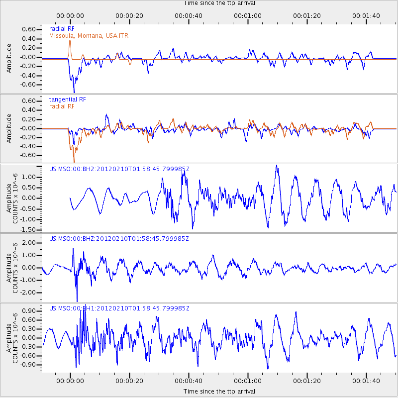
Signal To Noise
| Channel | StoN | STA | LTA |
| US:MSO:00:BHZ:20120210T01:58:45.799985Z | 2.24562 | 7.9750635E-7 | 3.551386E-7 |
| US:MSO:00:BH1:20120210T01:58:45.799985Z | 1.8349141 | 3.9501654E-7 | 2.1527795E-7 |
| US:MSO:00:BH2:20120210T01:58:45.799985Z | 1.5588998 | 4.5921772E-7 | 2.945781E-7 |
| Arrivals |
| Ps | |
| PpPs | |
| PsPs/PpSs | |


