You are here: Home > Network List > GS - US Geological Survey Networks Stations List
> Station DEC07 Harrison Ave Surface Site > Earthquake Result Viewer
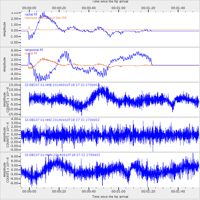
DEC07 Harrison Ave Surface Site - Earthquake Result Viewer
*The percent match for this event was below the threshold and hence no stack was calculated.
| Earthquake location: |
Rat Islands, Aleutian Islands |
| Earthquake latitude/longitude: |
52.1/178.3 |
| Earthquake time(UTC): |
2014/09/10 (253) 18:28:00 GMT |
| Earthquake Depth: |
125 km |
| Earthquake Magnitude: |
5.3 MW |
| Earthquake Catalog/Contributor: |
ISC/ISC |
|
| Network: |
GS US Geological Survey Networks |
| Station: |
DEC07 Harrison Ave Surface Site |
| Lat/Lon: |
39.86 N/88.90 W |
| Elevation: |
212 m |
|
| Distance: |
61.4 deg |
| Az: |
61.146 deg |
| Baz: |
315.388 deg |
| Ray Param: |
$rayparam |
*The percent match for this event was below the threshold and hence was not used in the summary stack. |
|
| Radial Match: |
71.96384 % |
| Radial Bump: |
400 |
| Transverse Match: |
79.609955 % |
| Transverse Bump: |
400 |
| SOD ConfigId: |
3390531 |
| Insert Time: |
2019-04-13 23:45:50.770 +0000 |
| GWidth: |
2.5 |
| Max Bumps: |
400 |
| Tol: |
0.001 |
|
Signal To Noise
| Channel | StoN | STA | LTA |
| GS:DEC07:01:HHZ:20140910T18:37:32.279993Z | 1.0865725 | 1.1377173E-6 | 1.0470698E-6 |
| GS:DEC07:01:HHN:20140910T18:37:32.279993Z | 1.8310912 | 5.508466E-6 | 3.008297E-6 |
| GS:DEC07:01:HHE:20140910T18:37:32.279993Z | 2.2931538 | 7.359945E-6 | 3.2095297E-6 |
| Arrivals |
| Ps | |
| PpPs | |
| PsPs/PpSs | |


