You are here: Home > Network List > IU - Global Seismograph Network (GSN - IRIS/USGS) Stations List
> Station HNR Honiara, Solomon Islands > Earthquake Result Viewer
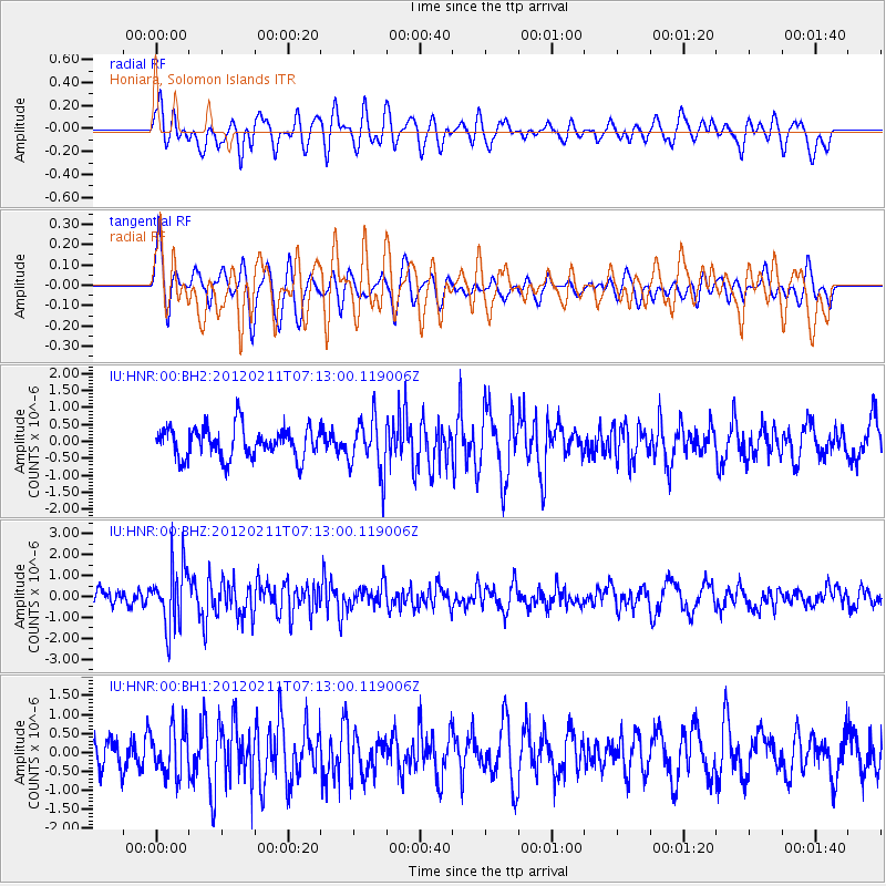
HNR Honiara, Solomon Islands - Earthquake Result Viewer
*The percent match for this event was below the threshold and hence no stack was calculated.
| Earthquake location: |
Southern Molucca Sea |
| Earthquake latitude/longitude: |
-1.0/126.9 |
| Earthquake time(UTC): |
2012/02/11 (042) 07:06:48 GMT |
| Earthquake Depth: |
19 km |
| Earthquake Magnitude: |
5.7 MB, 5.3 MS, 5.5 MW, 5.6 MW |
| Earthquake Catalog/Contributor: |
WHDF/NEIC |
|
| Network: |
IU Global Seismograph Network (GSN - IRIS/USGS) |
| Station: |
HNR Honiara, Solomon Islands |
| Lat/Lon: |
9.44 S/159.95 E |
| Elevation: |
100 m |
|
| Distance: |
34.0 deg |
| Az: |
105.449 deg |
| Baz: |
282.371 deg |
| Ray Param: |
$rayparam |
*The percent match for this event was below the threshold and hence was not used in the summary stack. |
|
| Radial Match: |
61.938114 % |
| Radial Bump: |
400 |
| Transverse Match: |
60.876637 % |
| Transverse Bump: |
400 |
| SOD ConfigId: |
558545 |
| Insert Time: |
2013-09-19 11:43:19.894 +0000 |
| GWidth: |
2.5 |
| Max Bumps: |
400 |
| Tol: |
0.001 |
|
Signal To Noise
| Channel | StoN | STA | LTA |
| IU:HNR:00:BHZ:20120211T07:13:00.119006Z | 3.7348237 | 1.474752E-6 | 3.9486522E-7 |
| IU:HNR:00:BH1:20120211T07:13:00.119006Z | 1.888837 | 6.239729E-7 | 3.3034766E-7 |
| IU:HNR:00:BH2:20120211T07:13:00.119006Z | 1.780706 | 8.091426E-7 | 4.5439424E-7 |
| Arrivals |
| Ps | |
| PpPs | |
| PsPs/PpSs | |


