You are here: Home > Network List > G - GEOSCOPE Stations List
> Station KIP Kipapa - Hawaii, USA > Earthquake Result Viewer
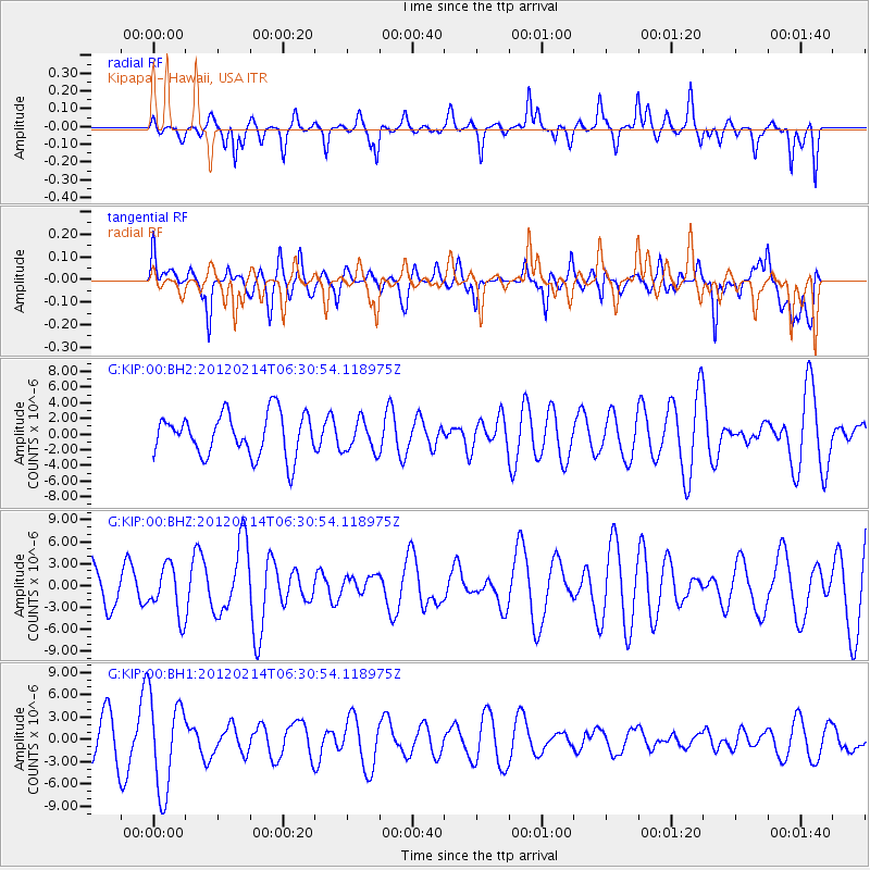
KIP Kipapa - Hawaii, USA - Earthquake Result Viewer
*The percent match for this event was below the threshold and hence no stack was calculated.
| Earthquake location: |
Near East Coast Of Honshu, Japan |
| Earthquake latitude/longitude: |
36.2/141.4 |
| Earthquake time(UTC): |
2012/02/14 (045) 06:22:01 GMT |
| Earthquake Depth: |
28 km |
| Earthquake Magnitude: |
5.6 MB, 5.6 MS, 5.8 MW, 5.7 MW |
| Earthquake Catalog/Contributor: |
WHDF/NEIC |
|
| Network: |
G GEOSCOPE |
| Station: |
KIP Kipapa - Hawaii, USA |
| Lat/Lon: |
21.42 N/158.01 W |
| Elevation: |
70 m |
|
| Distance: |
54.3 deg |
| Az: |
88.263 deg |
| Baz: |
299.825 deg |
| Ray Param: |
$rayparam |
*The percent match for this event was below the threshold and hence was not used in the summary stack. |
|
| Radial Match: |
52.219635 % |
| Radial Bump: |
400 |
| Transverse Match: |
43.65825 % |
| Transverse Bump: |
400 |
| SOD ConfigId: |
558545 |
| Insert Time: |
2013-09-19 11:54:06.123 +0000 |
| GWidth: |
2.5 |
| Max Bumps: |
400 |
| Tol: |
0.001 |
|
Signal To Noise
| Channel | StoN | STA | LTA |
| G:KIP:00:BHZ:20120214T06:30:54.118975Z | 1.0847973 | 3.386717E-6 | 3.1219815E-6 |
| G:KIP:00:BH1:20120214T06:30:54.118975Z | 1.9329656 | 6.2867707E-6 | 3.2523965E-6 |
| G:KIP:00:BH2:20120214T06:30:54.118975Z | 0.75111824 | 2.0158936E-6 | 2.6838566E-6 |
| Arrivals |
| Ps | |
| PpPs | |
| PsPs/PpSs | |


