You are here: Home > Network List > US - United States National Seismic Network Stations List
> Station DGMT Dagmar, Montana, USA > Earthquake Result Viewer
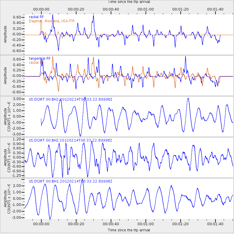
DGMT Dagmar, Montana, USA - Earthquake Result Viewer
*The percent match for this event was below the threshold and hence no stack was calculated.
| Earthquake location: |
Near East Coast Of Honshu, Japan |
| Earthquake latitude/longitude: |
36.2/141.4 |
| Earthquake time(UTC): |
2012/02/14 (045) 06:22:01 GMT |
| Earthquake Depth: |
28 km |
| Earthquake Magnitude: |
5.6 MB, 5.6 MS, 5.8 MW, 5.7 MW |
| Earthquake Catalog/Contributor: |
WHDF/NEIC |
|
| Network: |
US United States National Seismic Network |
| Station: |
DGMT Dagmar, Montana, USA |
| Lat/Lon: |
48.47 N/104.20 W |
| Elevation: |
0.0 m |
|
| Distance: |
77.5 deg |
| Az: |
38.367 deg |
| Baz: |
311.039 deg |
| Ray Param: |
$rayparam |
*The percent match for this event was below the threshold and hence was not used in the summary stack. |
|
| Radial Match: |
45.616703 % |
| Radial Bump: |
286 |
| Transverse Match: |
33.065758 % |
| Transverse Bump: |
248 |
| SOD ConfigId: |
558545 |
| Insert Time: |
2013-09-19 11:55:31.942 +0000 |
| GWidth: |
2.5 |
| Max Bumps: |
400 |
| Tol: |
0.001 |
|
Signal To Noise
| Channel | StoN | STA | LTA |
| US:DGMT:00:BHZ:20120214T06:33:22.89998Z | 1.3198534 | 3.8076323E-7 | 2.8848902E-7 |
| US:DGMT:00:BH1:20120214T06:33:22.89998Z | 2.4919953 | 1.6913157E-6 | 6.786994E-7 |
| US:DGMT:00:BH2:20120214T06:33:22.89998Z | 0.66420144 | 1.0846832E-6 | 1.6330637E-6 |
| Arrivals |
| Ps | |
| PpPs | |
| PsPs/PpSs | |


