You are here: Home > Network List > US - United States National Seismic Network Stations List
> Station MSO Missoula, Montana, USA > Earthquake Result Viewer
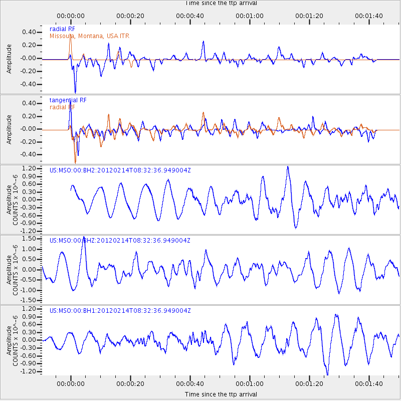
MSO Missoula, Montana, USA - Earthquake Result Viewer
*The percent match for this event was below the threshold and hence no stack was calculated.
| Earthquake location: |
Solomon Islands |
| Earthquake latitude/longitude: |
-10.4/161.1 |
| Earthquake time(UTC): |
2012/02/14 (045) 08:19:55 GMT |
| Earthquake Depth: |
51 km |
| Earthquake Magnitude: |
6.2 MB, 6.4 MW, 6.4 MW |
| Earthquake Catalog/Contributor: |
WHDF/NEIC |
|
| Network: |
US United States National Seismic Network |
| Station: |
MSO Missoula, Montana, USA |
| Lat/Lon: |
46.83 N/113.94 W |
| Elevation: |
1264 m |
|
| Distance: |
94.1 deg |
| Az: |
43.289 deg |
| Baz: |
259.259 deg |
| Ray Param: |
$rayparam |
*The percent match for this event was below the threshold and hence was not used in the summary stack. |
|
| Radial Match: |
72.13328 % |
| Radial Bump: |
400 |
| Transverse Match: |
59.714077 % |
| Transverse Bump: |
400 |
| SOD ConfigId: |
558545 |
| Insert Time: |
2013-09-19 11:58:40.415 +0000 |
| GWidth: |
2.5 |
| Max Bumps: |
400 |
| Tol: |
0.001 |
|
Signal To Noise
| Channel | StoN | STA | LTA |
| US:MSO:00:BHZ:20120214T08:32:36.949004Z | 2.6163788 | 8.8645425E-7 | 3.388096E-7 |
| US:MSO:00:BH1:20120214T08:32:36.949004Z | 1.2736269 | 3.030524E-7 | 2.3794439E-7 |
| US:MSO:00:BH2:20120214T08:32:36.949004Z | 1.3462358 | 5.381292E-7 | 3.9972878E-7 |
| Arrivals |
| Ps | |
| PpPs | |
| PsPs/PpSs | |


