You are here: Home > Network List > US - United States National Seismic Network Stations List
> Station WRAK Wrangell Island, Southeastern Alaska, Alaska, USA > Earthquake Result Viewer
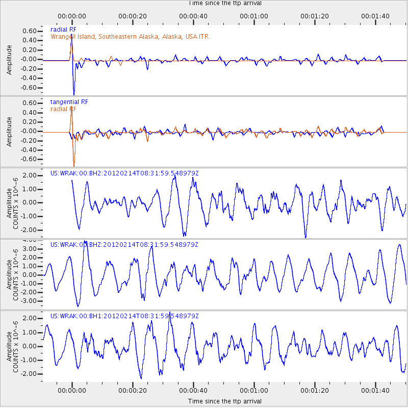
WRAK Wrangell Island, Southeastern Alaska, Alaska, USA - Earthquake Result Viewer
*The percent match for this event was below the threshold and hence no stack was calculated.
| Earthquake location: |
Solomon Islands |
| Earthquake latitude/longitude: |
-10.4/161.1 |
| Earthquake time(UTC): |
2012/02/14 (045) 08:19:55 GMT |
| Earthquake Depth: |
51 km |
| Earthquake Magnitude: |
6.2 MB, 6.4 MW, 6.4 MW |
| Earthquake Catalog/Contributor: |
WHDF/NEIC |
|
| Network: |
US United States National Seismic Network |
| Station: |
WRAK Wrangell Island, Southeastern Alaska, Alaska, USA |
| Lat/Lon: |
56.42 N/132.35 W |
| Elevation: |
81 m |
|
| Distance: |
86.1 deg |
| Az: |
30.731 deg |
| Baz: |
244.783 deg |
| Ray Param: |
$rayparam |
*The percent match for this event was below the threshold and hence was not used in the summary stack. |
|
| Radial Match: |
83.1985 % |
| Radial Bump: |
400 |
| Transverse Match: |
58.66539 % |
| Transverse Bump: |
400 |
| SOD ConfigId: |
558545 |
| Insert Time: |
2013-09-19 11:58:48.873 +0000 |
| GWidth: |
2.5 |
| Max Bumps: |
400 |
| Tol: |
0.001 |
|
Signal To Noise
| Channel | StoN | STA | LTA |
| US:WRAK:00:BHZ:20120214T08:31:59.548979Z | 1.8367523 | 2.5369595E-6 | 1.3812203E-6 |
| US:WRAK:00:BH1:20120214T08:31:59.548979Z | 1.0609705 | 8.964071E-7 | 8.448934E-7 |
| US:WRAK:00:BH2:20120214T08:31:59.548979Z | 2.0858629 | 1.2800394E-6 | 6.136738E-7 |
| Arrivals |
| Ps | |
| PpPs | |
| PsPs/PpSs | |


