You are here: Home > Network List > IU - Global Seismograph Network (GSN - IRIS/USGS) Stations List
> Station JOHN Johnston Island, USA > Earthquake Result Viewer
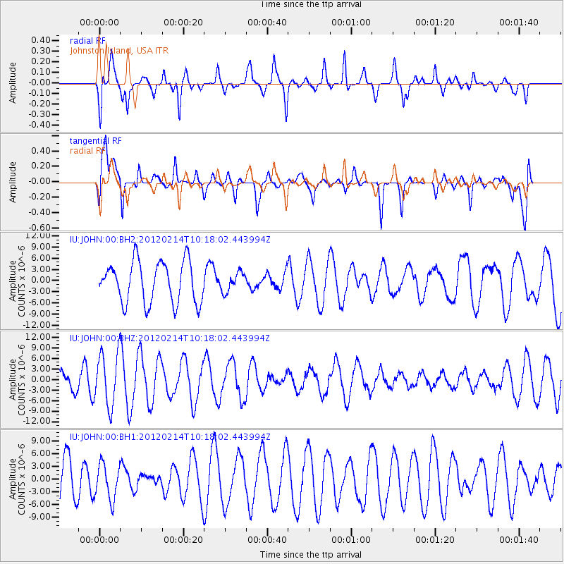
JOHN Johnston Island, USA - Earthquake Result Viewer
*The percent match for this event was below the threshold and hence no stack was calculated.
| Earthquake location: |
Calif.-Baja Calif. Border Region |
| Earthquake latitude/longitude: |
32.1/-115.2 |
| Earthquake time(UTC): |
2012/02/14 (045) 10:09:28 GMT |
| Earthquake Depth: |
4.7 km |
| Earthquake Magnitude: |
5.5 ML, 4.9 MW, 4.9 MB |
| Earthquake Catalog/Contributor: |
WHDF/NEIC |
|
| Network: |
IU Global Seismograph Network (GSN - IRIS/USGS) |
| Station: |
JOHN Johnston Island, USA |
| Lat/Lon: |
16.73 N/169.53 W |
| Elevation: |
2.0 m |
|
| Distance: |
51.3 deg |
| Az: |
266.127 deg |
| Baz: |
62.089 deg |
| Ray Param: |
$rayparam |
*The percent match for this event was below the threshold and hence was not used in the summary stack. |
|
| Radial Match: |
69.21364 % |
| Radial Bump: |
360 |
| Transverse Match: |
73.14492 % |
| Transverse Bump: |
400 |
| SOD ConfigId: |
558545 |
| Insert Time: |
2013-09-19 12:00:03.563 +0000 |
| GWidth: |
2.5 |
| Max Bumps: |
400 |
| Tol: |
0.001 |
|
Signal To Noise
| Channel | StoN | STA | LTA |
| IU:JOHN:00:BHZ:20120214T10:18:02.443994Z | 2.0709965 | 7.620742E-6 | 3.6797462E-6 |
| IU:JOHN:00:BH1:20120214T10:18:02.443994Z | 0.78007865 | 4.2156294E-6 | 5.4041084E-6 |
| IU:JOHN:00:BH2:20120214T10:18:02.443994Z | 0.47477943 | 2.6399082E-6 | 5.560283E-6 |
| Arrivals |
| Ps | |
| PpPs | |
| PsPs/PpSs | |


