You are here: Home > Network List > US - United States National Seismic Network Stations List
> Station MSO Missoula, Montana, USA > Earthquake Result Viewer
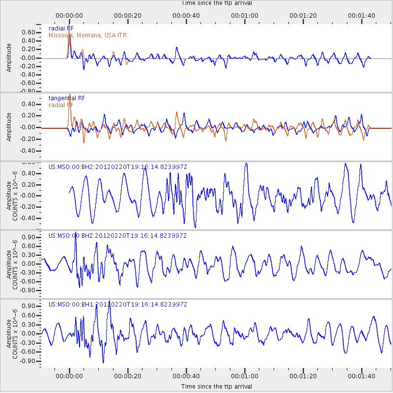
MSO Missoula, Montana, USA - Earthquake Result Viewer
*The percent match for this event was below the threshold and hence no stack was calculated.
| Earthquake location: |
Near Coast Of Chiapas, Mexico |
| Earthquake latitude/longitude: |
14.3/-92.8 |
| Earthquake time(UTC): |
2012/02/20 (051) 19:09:36 GMT |
| Earthquake Depth: |
10 km |
| Earthquake Magnitude: |
5.6 MW |
| Earthquake Catalog/Contributor: |
NEIC PDE/NEIC PDE-M |
|
| Network: |
US United States National Seismic Network |
| Station: |
MSO Missoula, Montana, USA |
| Lat/Lon: |
46.83 N/113.94 W |
| Elevation: |
1264 m |
|
| Distance: |
37.0 deg |
| Az: |
335.66 deg |
| Baz: |
144.412 deg |
| Ray Param: |
$rayparam |
*The percent match for this event was below the threshold and hence was not used in the summary stack. |
|
| Radial Match: |
60.663906 % |
| Radial Bump: |
400 |
| Transverse Match: |
39.93454 % |
| Transverse Bump: |
400 |
| SOD ConfigId: |
558545 |
| Insert Time: |
2013-09-19 12:10:28.262 +0000 |
| GWidth: |
2.5 |
| Max Bumps: |
400 |
| Tol: |
0.001 |
|
Signal To Noise
| Channel | StoN | STA | LTA |
| US:MSO:00:BHZ:20120220T19:16:14.823997Z | 2.8400552 | 4.1327664E-7 | 1.455171E-7 |
| US:MSO:00:BH1:20120220T19:16:14.823997Z | 1.3461902 | 2.461618E-7 | 1.8285812E-7 |
| US:MSO:00:BH2:20120220T19:16:14.823997Z | 0.91898066 | 2.0369323E-7 | 2.2165128E-7 |
| Arrivals |
| Ps | |
| PpPs | |
| PsPs/PpSs | |


