You are here: Home > Network List > US - United States National Seismic Network Stations List
> Station WVOR Wild Horse Valley, Oregon, USA > Earthquake Result Viewer
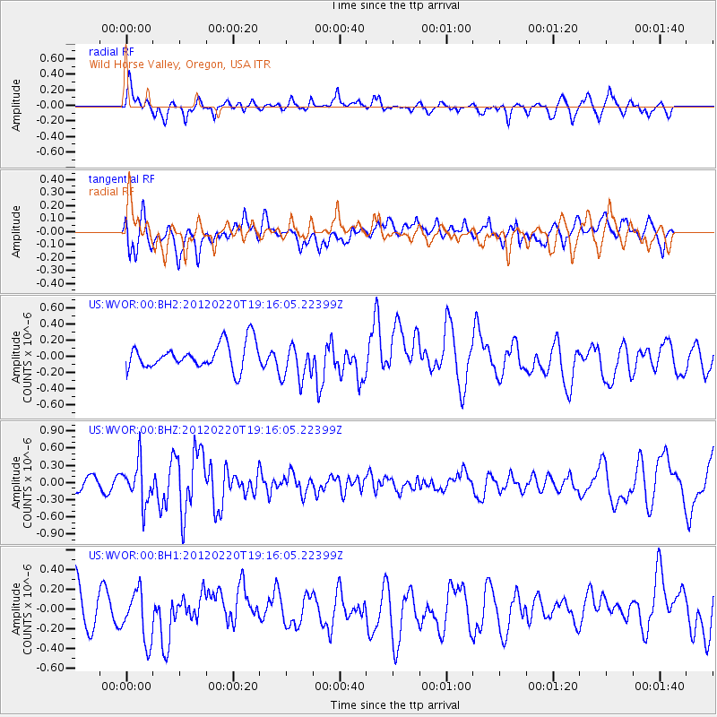
WVOR Wild Horse Valley, Oregon, USA - Earthquake Result Viewer
*The percent match for this event was below the threshold and hence no stack was calculated.
| Earthquake location: |
Near Coast Of Chiapas, Mexico |
| Earthquake latitude/longitude: |
14.3/-92.8 |
| Earthquake time(UTC): |
2012/02/20 (051) 19:09:36 GMT |
| Earthquake Depth: |
10 km |
| Earthquake Magnitude: |
5.6 MW |
| Earthquake Catalog/Contributor: |
NEIC PDE/NEIC PDE-M |
|
| Network: |
US United States National Seismic Network |
| Station: |
WVOR Wild Horse Valley, Oregon, USA |
| Lat/Lon: |
42.43 N/118.64 W |
| Elevation: |
1344 m |
|
| Distance: |
35.8 deg |
| Az: |
326.539 deg |
| Baz: |
133.773 deg |
| Ray Param: |
$rayparam |
*The percent match for this event was below the threshold and hence was not used in the summary stack. |
|
| Radial Match: |
51.36957 % |
| Radial Bump: |
380 |
| Transverse Match: |
41.912907 % |
| Transverse Bump: |
400 |
| SOD ConfigId: |
558545 |
| Insert Time: |
2013-09-19 12:10:56.732 +0000 |
| GWidth: |
2.5 |
| Max Bumps: |
400 |
| Tol: |
0.001 |
|
Signal To Noise
| Channel | StoN | STA | LTA |
| US:WVOR:00:BHZ:20120220T19:16:05.22399Z | 2.7734332 | 3.565102E-7 | 1.2854473E-7 |
| US:WVOR:00:BH1:20120220T19:16:05.22399Z | 1.3199879 | 2.641617E-7 | 2.0012433E-7 |
| US:WVOR:00:BH2:20120220T19:16:05.22399Z | 1.4464235 | 2.2806347E-7 | 1.5767405E-7 |
| Arrivals |
| Ps | |
| PpPs | |
| PsPs/PpSs | |


