You are here: Home > Network List > II - Global Seismograph Network (GSN - IRIS/IDA) Stations List
> Station AAK Ala Archa, Kyrgyzstan > Earthquake Result Viewer
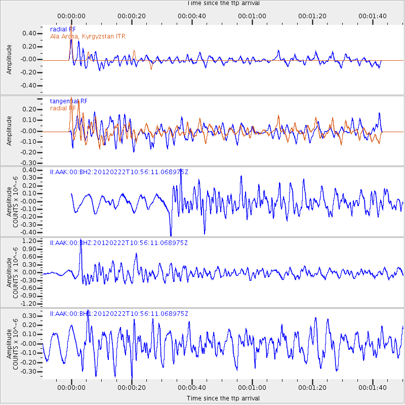
AAK Ala Archa, Kyrgyzstan - Earthquake Result Viewer
*The percent match for this event was below the threshold and hence no stack was calculated.
| Earthquake location: |
Aru Islands Region, Indonesia |
| Earthquake latitude/longitude: |
-5.2/133.6 |
| Earthquake time(UTC): |
2012/02/22 (053) 10:45:22 GMT |
| Earthquake Depth: |
19 km |
| Earthquake Magnitude: |
5.5 MW, 5.8 MB |
| Earthquake Catalog/Contributor: |
NEIC PDE/NEIC PDE-M |
|
| Network: |
II Global Seismograph Network (GSN - IRIS/IDA) |
| Station: |
AAK Ala Archa, Kyrgyzstan |
| Lat/Lon: |
42.64 N/74.49 E |
| Elevation: |
1645 m |
|
| Distance: |
71.5 deg |
| Az: |
318.129 deg |
| Baz: |
115.722 deg |
| Ray Param: |
$rayparam |
*The percent match for this event was below the threshold and hence was not used in the summary stack. |
|
| Radial Match: |
74.33377 % |
| Radial Bump: |
400 |
| Transverse Match: |
65.40728 % |
| Transverse Bump: |
400 |
| SOD ConfigId: |
558545 |
| Insert Time: |
2013-09-19 12:11:10.579 +0000 |
| GWidth: |
2.5 |
| Max Bumps: |
400 |
| Tol: |
0.001 |
|
Signal To Noise
| Channel | StoN | STA | LTA |
| II:AAK:00:BHZ:20120222T10:56:11.068975Z | 6.8802795 | 4.002825E-7 | 5.8178234E-8 |
| II:AAK:00:BH1:20120222T10:56:11.068975Z | 1.7048273 | 1.3405739E-7 | 7.8633995E-8 |
| II:AAK:00:BH2:20120222T10:56:11.068975Z | 2.136294 | 1.5263576E-7 | 7.144886E-8 |
| Arrivals |
| Ps | |
| PpPs | |
| PsPs/PpSs | |


