You are here: Home > Network List > TA - USArray Transportable Network (new EarthScope stations) Stations List
> Station O03E Paynes Creek, CA, USA > Earthquake Result Viewer
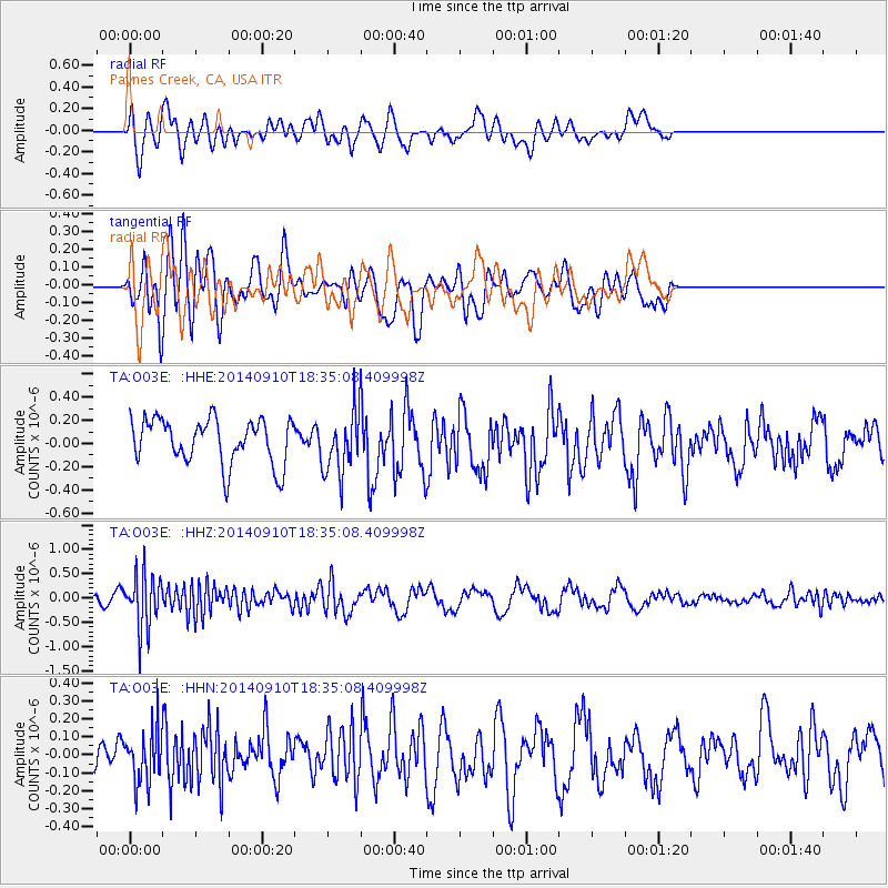
O03E Paynes Creek, CA, USA - Earthquake Result Viewer
*The percent match for this event was below the threshold and hence no stack was calculated.
| Earthquake location: |
Rat Islands, Aleutian Islands |
| Earthquake latitude/longitude: |
52.1/178.3 |
| Earthquake time(UTC): |
2014/09/10 (253) 18:28:00 GMT |
| Earthquake Depth: |
125 km |
| Earthquake Magnitude: |
5.3 MW |
| Earthquake Catalog/Contributor: |
ISC/ISC |
|
| Network: |
TA USArray Transportable Network (new EarthScope stations) |
| Station: |
O03E Paynes Creek, CA, USA |
| Lat/Lon: |
40.29 N/121.80 W |
| Elevation: |
967 m |
|
| Distance: |
42.0 deg |
| Az: |
81.771 deg |
| Baz: |
307.005 deg |
| Ray Param: |
$rayparam |
*The percent match for this event was below the threshold and hence was not used in the summary stack. |
|
| Radial Match: |
65.878944 % |
| Radial Bump: |
400 |
| Transverse Match: |
47.761337 % |
| Transverse Bump: |
400 |
| SOD ConfigId: |
3390531 |
| Insert Time: |
2019-04-13 23:50:05.401 +0000 |
| GWidth: |
2.5 |
| Max Bumps: |
400 |
| Tol: |
0.001 |
|
Signal To Noise
| Channel | StoN | STA | LTA |
| TA:O03E: :HHZ:20140910T18:35:08.409998Z | 4.4363093 | 5.4810033E-7 | 1.2354872E-7 |
| TA:O03E: :HHN:20140910T18:35:08.409998Z | 1.0812738 | 1.4183314E-7 | 1.3117229E-7 |
| TA:O03E: :HHE:20140910T18:35:08.409998Z | 1.3398335 | 2.606741E-7 | 1.9455709E-7 |
| Arrivals |
| Ps | |
| PpPs | |
| PsPs/PpSs | |


