You are here: Home > Network List > CN - Canadian National Seismograph Network Stations List
> Station MBC > Earthquake Result Viewer
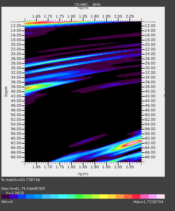
MBC - Earthquake Result Viewer
| Earthquake location: |
East Of Kuril Islands |
| Earthquake latitude/longitude: |
44.7/150.0 |
| Earthquake time(UTC): |
1994/08/14 (226) 01:31:14 GMT |
| Earthquake Depth: |
33 km |
| Earthquake Magnitude: |
6.1 MB, 6.0 MS, 5.6 UNKNOWN, 6.5 MW |
| Earthquake Catalog/Contributor: |
WHDF/NEIC |
|
| Network: |
CN Canadian National Seismograph Network |
| Station: |
MBC |
| Lat/Lon: |
76.24 N/119.36 W |
| Elevation: |
15 m |
|
| Distance: |
47.3 deg |
| Az: |
19.013 deg |
| Baz: |
283.811 deg |
| Ray Param: |
0.0700327 |
| Estimated Moho Depth: |
61.75 km |
| Estimated Crust Vp/Vs: |
2.06 |
| Assumed Crust Vp: |
6.391 km/s |
| Estimated Crust Vs: |
3.098 km/s |
| Estimated Crust Poisson's Ratio: |
0.35 |
|
| Radial Match: |
83.739746 % |
| Radial Bump: |
400 |
| Transverse Match: |
76.309135 % |
| Transverse Bump: |
400 |
| SOD ConfigId: |
4480 |
| Insert Time: |
2010-02-27 06:43:04.992 +0000 |
| GWidth: |
2.5 |
| Max Bumps: |
400 |
| Tol: |
0.001 |
|

Signal To Noise
| Channel | StoN | STA | LTA |
| CN:MBC: :BHN:19940814T01:39:14.349011Z | 12.5773535 | 6.125786E-5 | 4.8704887E-6 |
| CN:MBC: :BHE:19940814T01:39:14.349011Z | 0.66540617 | 4.5262736E-6 | 6.802272E-6 |
| CN:MBC: :BHZ:19940814T01:39:14.349011Z | 4.696377 | 2.2202257E-5 | 4.727529E-6 |
| Arrivals |
| Ps | 11 SECOND |
| PpPs | 28 SECOND |
| PsPs/PpSs | 39 SECOND |


