You are here: Home > Network List > US - United States National Seismic Network Stations List
> Station DUG Dugway, Tooele County, Utah, USA > Earthquake Result Viewer
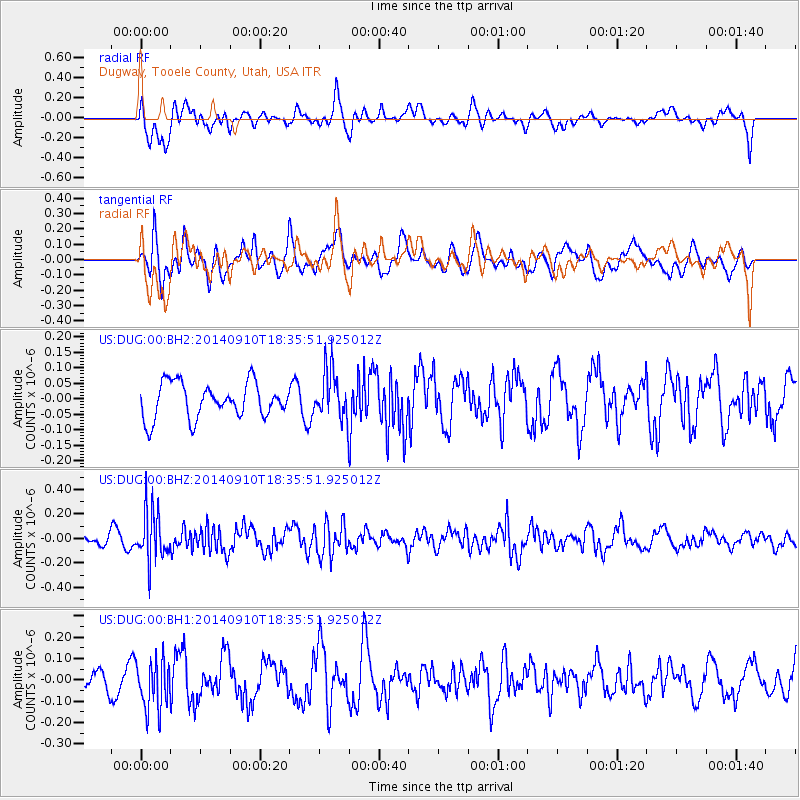
DUG Dugway, Tooele County, Utah, USA - Earthquake Result Viewer
*The percent match for this event was below the threshold and hence no stack was calculated.
| Earthquake location: |
Rat Islands, Aleutian Islands |
| Earthquake latitude/longitude: |
52.1/178.3 |
| Earthquake time(UTC): |
2014/09/10 (253) 18:28:00 GMT |
| Earthquake Depth: |
125 km |
| Earthquake Magnitude: |
5.3 MW |
| Earthquake Catalog/Contributor: |
ISC/ISC |
|
| Network: |
US United States National Seismic Network |
| Station: |
DUG Dugway, Tooele County, Utah, USA |
| Lat/Lon: |
40.19 N/112.81 W |
| Elevation: |
1477 m |
|
| Distance: |
47.5 deg |
| Az: |
75.89 deg |
| Baz: |
308.61 deg |
| Ray Param: |
$rayparam |
*The percent match for this event was below the threshold and hence was not used in the summary stack. |
|
| Radial Match: |
51.900284 % |
| Radial Bump: |
400 |
| Transverse Match: |
63.830376 % |
| Transverse Bump: |
400 |
| SOD ConfigId: |
3390531 |
| Insert Time: |
2019-04-13 23:51:04.715 +0000 |
| GWidth: |
2.5 |
| Max Bumps: |
400 |
| Tol: |
0.001 |
|
Signal To Noise
| Channel | StoN | STA | LTA |
| US:DUG:00:BHZ:20140910T18:35:51.925012Z | 3.9697125 | 1.9610144E-7 | 4.9399407E-8 |
| US:DUG:00:BH1:20140910T18:35:51.925012Z | 2.0439062 | 1.1744278E-7 | 5.745996E-8 |
| US:DUG:00:BH2:20140910T18:35:51.925012Z | 1.3592702 | 7.6840756E-8 | 5.653089E-8 |
| Arrivals |
| Ps | |
| PpPs | |
| PsPs/PpSs | |


