You are here: Home > Network List > X812 - Deep Structure of Three Continental Sutures in Eastern North America Stations List
> Station QM20 Hay Lake, Maine, USA > Earthquake Result Viewer
QM20 Hay Lake, Maine, USA - Earthquake Result Viewer
*The percent match for this event was below the threshold and hence no stack was calculated.
| Earthquake location: |
Rat Islands, Aleutian Islands |
| Earthquake latitude/longitude: |
52.1/178.3 |
| Earthquake time(UTC): |
2014/09/10 (253) 18:28:00 GMT |
| Earthquake Depth: |
125 km |
| Earthquake Magnitude: |
5.3 MW |
| Earthquake Catalog/Contributor: |
ISC/ISC |
|
| Network: |
X8 Deep Structure of Three Continental Sutures in Eastern North America |
| Station: |
QM20 Hay Lake, Maine, USA |
| Lat/Lon: |
46.13 N/68.72 W |
| Elevation: |
207 m |
|
| Distance: |
66.6 deg |
| Az: |
44.259 deg |
| Baz: |
321.733 deg |
| Ray Param: |
$rayparam |
*The percent match for this event was below the threshold and hence was not used in the summary stack. |
|
| Radial Match: |
46.817364 % |
| Radial Bump: |
400 |
| Transverse Match: |
57.305416 % |
| Transverse Bump: |
400 |
| SOD ConfigId: |
3390531 |
| Insert Time: |
2019-04-13 23:51:58.954 +0000 |
| GWidth: |
2.5 |
| Max Bumps: |
400 |
| Tol: |
0.001 |
|
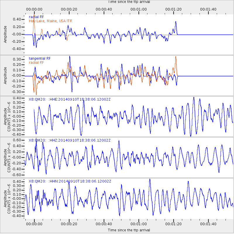
Signal To Noise
| Channel | StoN | STA | LTA |
| X8:QM20: :HHZ:20140910T18:38:06.12002Z | 1.2447766 | 2.8738904E-7 | 2.3087601E-7 |
| X8:QM20: :HHN:20140910T18:38:06.12002Z | 1.3736085 | 1.9795387E-7 | 1.4411229E-7 |
| X8:QM20: :HHE:20140910T18:38:06.12002Z | 0.7874208 | 1.1100422E-7 | 1.4097192E-7 |
| Arrivals |
| Ps | |
| PpPs | |
| PsPs/PpSs | |


