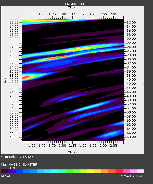
MBC Mould Bay, Northwest Territories, Canada - Earthquake Result Viewer

Earthquake location: Bonin Islands, Japan Region
Earthquake latitude/longitude: 28.0/143.5
Earthquake time(UTC): 1996/11/06 (311) 20:00:58 GMT
Earthquake Depth: 9.0 km
Earthquake Magnitude: 6.4 MB, 6.5 MS, 6.6 UNKNOWN, 6.4 ME
Earthquake Catalog/Contributor: WHDF/NEIC
Network: CN Canadian National Seismograph Network
Station: MBC Mould Bay, Northwest Territories, Canada
Lat/Lon: 76.24 N/119.36 W
Elevation: 15 m
Distance: 64.7 deg
Az: 15.229 deg
Baz: 283.947 deg
Ray Param: 0.058752436
Estimated Moho Depth: 38.5 km
Estimated Crust Vp/Vs: 1.60
Assumed Crust Vp: 6.391 km/s
Estimated Crust Vs: 3.994 km/s
Estimated Crust Poisson's Ratio: 0.18
Radial Match: 87.15809 %
Radial Bump: 400
Transverse Match: 88.27327 %
Transverse Bump: 400
SOD ConfigId: 4480
Insert Time: 2010-02-27 06:43:24.331 +0000
GWidth: 2.5
Max Bumps: 400
Tol: 0.001

Signal To Noise

ChannelStoNSTALTA
CN:MBC: :BHZ:19961106T20:11:05.950024Z3.21556191.0241127E-63.184864E-7
CN:MBC: :BHN:19961106T20:11:05.950024Z2.31381031.7535984E-77.5788336E-8
CN:MBC: :BHE:19961106T20:11:05.950024Z1.9279323.8103664E-71.9764008E-7
Arrivals
Ps3.8 SECOND
PpPs15 SECOND
PsPs/PpSs19 SECOND