You are here: Home > Network List > CN - Canadian National Seismograph Network Stations List
> Station MBC Mould Bay, Northwest Territories, Canada > Earthquake Result Viewer
MBC Mould Bay, Northwest Territories, Canada - Earthquake Result Viewer
| Earthquake location: |
Luzon, Philippines |
| Earthquake latitude/longitude: |
16.3/120.5 |
| Earthquake time(UTC): |
1996/11/20 (325) 17:58:04 GMT |
| Earthquake Depth: |
33 km |
| Earthquake Magnitude: |
5.7 MB, 5.7 MS, 6.0 UNKNOWN, 5.9 MW |
| Earthquake Catalog/Contributor: |
WHDF/NEIC |
|
| Network: |
CN Canadian National Seismograph Network |
| Station: |
MBC Mould Bay, Northwest Territories, Canada |
| Lat/Lon: |
76.24 N/119.36 W |
| Elevation: |
15 m |
|
| Distance: |
81.0 deg |
| Az: |
12.1 deg |
| Baz: |
302.771 deg |
| Ray Param: |
0.04784432 |
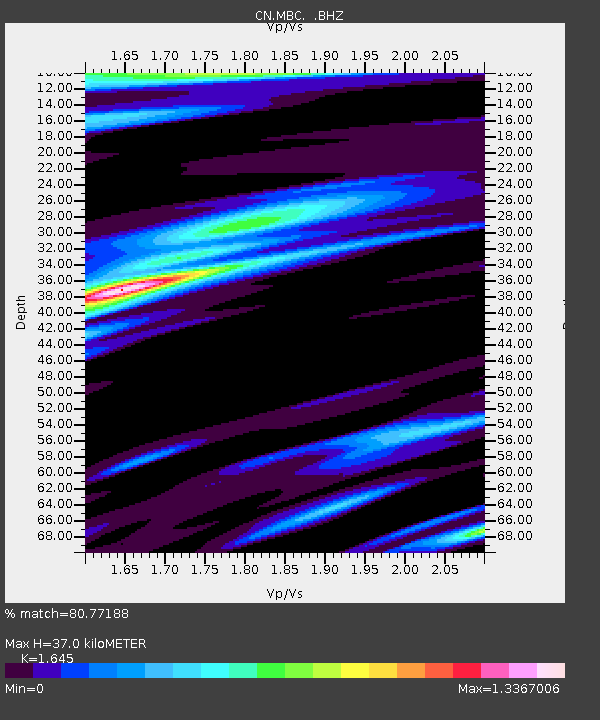
| Estimated Moho Depth: |
37.0 km |
| Estimated Crust Vp/Vs: |
1.64 |
| Assumed Crust Vp: |
6.391 km/s |
| Estimated Crust Vs: |
3.885 km/s |
| Estimated Crust Poisson's Ratio: |
0.21 |
|
| Radial Match: |
80.77188 % |
| Radial Bump: |
400 |
| Transverse Match: |
55.551357 % |
| Transverse Bump: |
400 |
| SOD ConfigId: |
4480 |
| Insert Time: |
2010-02-27 06:43:38.897 +0000 |
| GWidth: |
2.5 |
| Max Bumps: |
400 |
| Tol: |
0.001 |
|

Signal To Noise
| Channel | StoN | STA | LTA |
| CN:MBC: :BHZ:19961120T18:09:44.899011Z | 6.8688974 | 8.863707E-7 | 1.2904118E-7 |
| CN:MBC: :BHN:19961120T18:09:44.899011Z | 0.9623285 | 1.2881398E-7 | 1.3385656E-7 |
| CN:MBC: :BHE:19961120T18:09:44.899011Z | 0.99424803 | 1.3266667E-7 | 1.3343418E-7 |
| Arrivals |
| Ps | 3.8 SECOND |
| PpPs | 15 SECOND |
| PsPs/PpSs | 19 SECOND |


