You are here: Home > Network List > CN - Canadian National Seismograph Network Stations List
> Station MBC Mould Bay, Northwest Territories, Canada > Earthquake Result Viewer
MBC Mould Bay, Northwest Territories, Canada - Earthquake Result Viewer
| Earthquake location: |
Eastern Sea Of Japan |
| Earthquake latitude/longitude: |
43.2/138.9 |
| Earthquake time(UTC): |
1996/12/22 (357) 14:53:27 GMT |
| Earthquake Depth: |
227 km |
| Earthquake Magnitude: |
6.0 MB, 6.5 UNKNOWN, 6.5 MW |
| Earthquake Catalog/Contributor: |
WHDF/NEIC |
|
| Network: |
CN Canadian National Seismograph Network |
| Station: |
MBC Mould Bay, Northwest Territories, Canada |
| Lat/Lon: |
76.24 N/119.36 W |
| Elevation: |
15 m |
|
| Distance: |
51.2 deg |
| Az: |
17.504 deg |
| Baz: |
293.243 deg |
| Ray Param: |
0.06674368 |
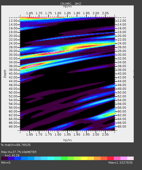
| Estimated Moho Depth: |
27.75 km |
| Estimated Crust Vp/Vs: |
1.81 |
| Assumed Crust Vp: |
6.391 km/s |
| Estimated Crust Vs: |
3.526 km/s |
| Estimated Crust Poisson's Ratio: |
0.28 |
|
| Radial Match: |
86.76535 % |
| Radial Bump: |
400 |
| Transverse Match: |
90.36827 % |
| Transverse Bump: |
400 |
| SOD ConfigId: |
4480 |
| Insert Time: |
2010-02-27 06:43:43.933 +0000 |
| GWidth: |
2.5 |
| Max Bumps: |
400 |
| Tol: |
0.001 |
|

Signal To Noise
| Channel | StoN | STA | LTA |
| CN:MBC: :BHZ:19961222T15:01:36.950006Z | 99.26814 | 1.4352104E-5 | 1.4457915E-7 |
| CN:MBC: :BHN:19961222T15:01:36.950006Z | 11.175074 | 1.7856577E-6 | 1.5978935E-7 |
| CN:MBC: :BHE:19961222T15:01:36.950006Z | 33.995277 | 4.326949E-6 | 1.2728087E-7 |
| Arrivals |
| Ps | 3.7 SECOND |
| PpPs | 12 SECOND |
| PsPs/PpSs | 15 SECOND |


