You are here: Home > Network List > IU - Global Seismograph Network (GSN - IRIS/USGS) Stations List
> Station MAKZ Makanchi, Kazakhstan > Earthquake Result Viewer
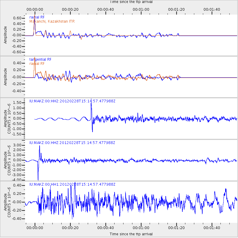
MAKZ Makanchi, Kazakhstan - Earthquake Result Viewer
*The percent match for this event was below the threshold and hence no stack was calculated.
| Earthquake location: |
Bonin Islands, Japan Region |
| Earthquake latitude/longitude: |
28.2/139.4 |
| Earthquake time(UTC): |
2012/02/28 (059) 15:07:35 GMT |
| Earthquake Depth: |
504 km |
| Earthquake Magnitude: |
5.6 MW, 5.6 MW |
| Earthquake Catalog/Contributor: |
NEIC PDE/NEIC PDE-M |
|
| Network: |
IU Global Seismograph Network (GSN - IRIS/USGS) |
| Station: |
MAKZ Makanchi, Kazakhstan |
| Lat/Lon: |
46.81 N/81.98 E |
| Elevation: |
600 m |
|
| Distance: |
48.1 deg |
| Az: |
308.933 deg |
| Baz: |
91.738 deg |
| Ray Param: |
$rayparam |
*The percent match for this event was below the threshold and hence was not used in the summary stack. |
|
| Radial Match: |
62.820858 % |
| Radial Bump: |
386 |
| Transverse Match: |
62.98566 % |
| Transverse Bump: |
400 |
| SOD ConfigId: |
558545 |
| Insert Time: |
2013-09-19 12:40:02.137 +0000 |
| GWidth: |
2.5 |
| Max Bumps: |
400 |
| Tol: |
0.001 |
|
Signal To Noise
| Channel | StoN | STA | LTA |
| IU:MAKZ:00:HHZ:20120228T15:14:57.477988Z | 10.294737 | 1.0808944E-6 | 1.04994854E-7 |
| IU:MAKZ:00:HH1:20120228T15:14:57.477988Z | 2.1308966 | 1.2346744E-7 | 5.794155E-8 |
| IU:MAKZ:00:HH2:20120228T15:14:57.477988Z | 6.535561 | 4.83369E-7 | 7.3959825E-8 |
| Arrivals |
| Ps | |
| PpPs | |
| PsPs/PpSs | |


