You are here: Home > Network List > IU - Global Seismograph Network (GSN - IRIS/USGS) Stations List
> Station PMG Port Moresby, New Guinea > Earthquake Result Viewer
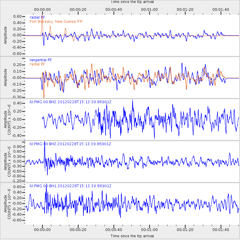
PMG Port Moresby, New Guinea - Earthquake Result Viewer
*The percent match for this event was below the threshold and hence no stack was calculated.
| Earthquake location: |
Bonin Islands, Japan Region |
| Earthquake latitude/longitude: |
28.2/139.4 |
| Earthquake time(UTC): |
2012/02/28 (059) 15:07:35 GMT |
| Earthquake Depth: |
504 km |
| Earthquake Magnitude: |
5.6 MW, 5.6 MW |
| Earthquake Catalog/Contributor: |
NEIC PDE/NEIC PDE-M |
|
| Network: |
IU Global Seismograph Network (GSN - IRIS/USGS) |
| Station: |
PMG Port Moresby, New Guinea |
| Lat/Lon: |
9.40 S/147.16 E |
| Elevation: |
90 m |
|
| Distance: |
38.1 deg |
| Az: |
167.525 deg |
| Baz: |
348.859 deg |
| Ray Param: |
$rayparam |
*The percent match for this event was below the threshold and hence was not used in the summary stack. |
|
| Radial Match: |
53.85269 % |
| Radial Bump: |
400 |
| Transverse Match: |
39.994453 % |
| Transverse Bump: |
400 |
| SOD ConfigId: |
558545 |
| Insert Time: |
2013-09-19 12:40:11.455 +0000 |
| GWidth: |
2.5 |
| Max Bumps: |
400 |
| Tol: |
0.001 |
|
Signal To Noise
| Channel | StoN | STA | LTA |
| IU:PMG:00:BHZ:20120228T15:13:39.86901Z | 4.052503 | 3.3554858E-7 | 8.280033E-8 |
| IU:PMG:00:BH1:20120228T15:13:39.86901Z | 2.2058728 | 2.42014E-7 | 1.097135E-7 |
| IU:PMG:00:BH2:20120228T15:13:39.86901Z | 1.6734911 | 1.693492E-7 | 1.0119516E-7 |
| Arrivals |
| Ps | |
| PpPs | |
| PsPs/PpSs | |


