You are here: Home > Network List > US - United States National Seismic Network Stations List
> Station LKWY Lake (Yellowstone--Lake), Wyoming, USA > Earthquake Result Viewer
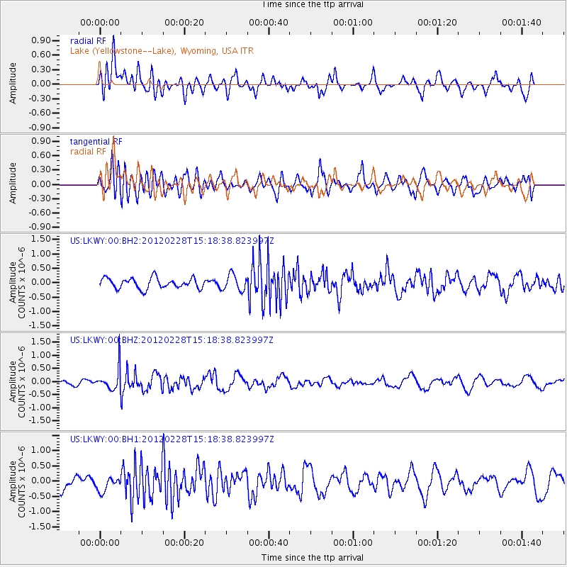
LKWY Lake (Yellowstone--Lake), Wyoming, USA - Earthquake Result Viewer
*The percent match for this event was below the threshold and hence no stack was calculated.
| Earthquake location: |
Bonin Islands, Japan Region |
| Earthquake latitude/longitude: |
28.2/139.4 |
| Earthquake time(UTC): |
2012/02/28 (059) 15:07:35 GMT |
| Earthquake Depth: |
504 km |
| Earthquake Magnitude: |
5.6 MW, 5.6 MW |
| Earthquake Catalog/Contributor: |
NEIC PDE/NEIC PDE-M |
|
| Network: |
US United States National Seismic Network |
| Station: |
LKWY Lake (Yellowstone--Lake), Wyoming, USA |
| Lat/Lon: |
44.57 N/110.40 W |
| Elevation: |
2424 m |
|
| Distance: |
83.6 deg |
| Az: |
42.451 deg |
| Baz: |
303.549 deg |
| Ray Param: |
$rayparam |
*The percent match for this event was below the threshold and hence was not used in the summary stack. |
|
| Radial Match: |
62.072693 % |
| Radial Bump: |
400 |
| Transverse Match: |
62.24255 % |
| Transverse Bump: |
400 |
| SOD ConfigId: |
558545 |
| Insert Time: |
2013-09-19 12:40:55.673 +0000 |
| GWidth: |
2.5 |
| Max Bumps: |
400 |
| Tol: |
0.001 |
|
Signal To Noise
| Channel | StoN | STA | LTA |
| US:LKWY:00:BHZ:20120228T15:18:38.823997Z | 4.0731497 | 4.3085018E-7 | 1.05778135E-7 |
| US:LKWY:00:BH1:20120228T15:18:38.823997Z | 0.9402007 | 2.4164436E-7 | 2.570136E-7 |
| US:LKWY:00:BH2:20120228T15:18:38.823997Z | 1.572701 | 2.830333E-7 | 1.7996638E-7 |
| Arrivals |
| Ps | |
| PpPs | |
| PsPs/PpSs | |


