You are here: Home > Network List > US - United States National Seismic Network Stations List
> Station OGNE Ogallala, Nebraska, USA > Earthquake Result Viewer
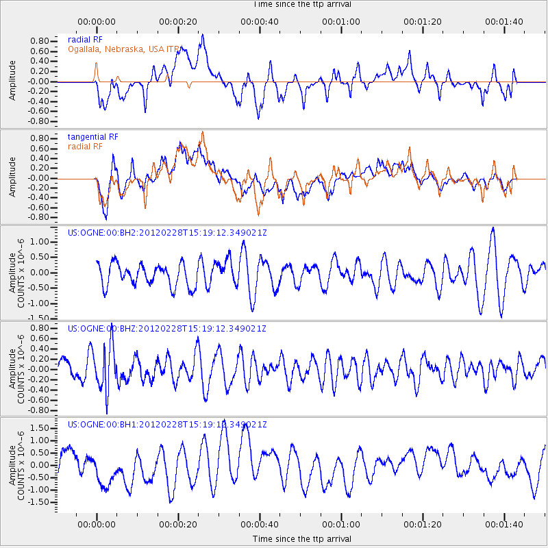
OGNE Ogallala, Nebraska, USA - Earthquake Result Viewer
*The percent match for this event was below the threshold and hence no stack was calculated.
| Earthquake location: |
Bonin Islands, Japan Region |
| Earthquake latitude/longitude: |
28.2/139.4 |
| Earthquake time(UTC): |
2012/02/28 (059) 15:07:35 GMT |
| Earthquake Depth: |
504 km |
| Earthquake Magnitude: |
5.6 MW, 5.6 MW |
| Earthquake Catalog/Contributor: |
NEIC PDE/NEIC PDE-M |
|
| Network: |
US United States National Seismic Network |
| Station: |
OGNE Ogallala, Nebraska, USA |
| Lat/Lon: |
40.95 N/102.03 W |
| Elevation: |
0.0 m |
|
| Distance: |
90.7 deg |
| Az: |
41.705 deg |
| Baz: |
309.18 deg |
| Ray Param: |
$rayparam |
*The percent match for this event was below the threshold and hence was not used in the summary stack. |
|
| Radial Match: |
60.829704 % |
| Radial Bump: |
400 |
| Transverse Match: |
65.079895 % |
| Transverse Bump: |
400 |
| SOD ConfigId: |
558545 |
| Insert Time: |
2013-09-19 12:41:02.152 +0000 |
| GWidth: |
2.5 |
| Max Bumps: |
400 |
| Tol: |
0.001 |
|
Signal To Noise
| Channel | StoN | STA | LTA |
| US:OGNE:00:BHZ:20120228T15:19:12.349021Z | 1.8991119 | 4.367496E-7 | 2.299757E-7 |
| US:OGNE:00:BH1:20120228T15:19:12.349021Z | 1.5861907 | 8.198584E-7 | 5.1687255E-7 |
| US:OGNE:00:BH2:20120228T15:19:12.349021Z | 1.1653894 | 4.1419202E-7 | 3.5541083E-7 |
| Arrivals |
| Ps | |
| PpPs | |
| PsPs/PpSs | |


