You are here: Home > Network List > CN - Canadian National Seismograph Network Stations List
> Station MBC Mould Bay, Northwest Territories, Canada > Earthquake Result Viewer
MBC Mould Bay, Northwest Territories, Canada - Earthquake Result Viewer
| Earthquake location: |
Mariana Islands |
| Earthquake latitude/longitude: |
18.5/146.9 |
| Earthquake time(UTC): |
1996/06/04 (156) 23:22:05 GMT |
| Earthquake Depth: |
59 km |
| Earthquake Magnitude: |
5.3 MB, 5.6 MS, 6.0 UNKNOWN, 5.8 MW |
| Earthquake Catalog/Contributor: |
WHDF/NEIC |
|
| Network: |
CN Canadian National Seismograph Network |
| Station: |
MBC Mould Bay, Northwest Territories, Canada |
| Lat/Lon: |
76.24 N/119.36 W |
| Elevation: |
15 m |
|
| Distance: |
73.1 deg |
| Az: |
14.454 deg |
| Baz: |
278.166 deg |
| Ray Param: |
0.053109083 |
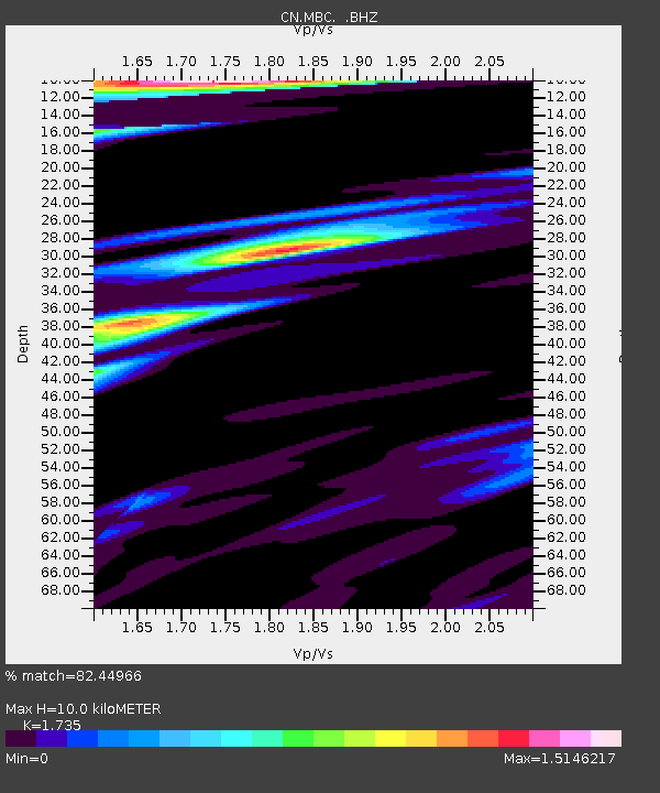
| Estimated Moho Depth: |
10.0 km |
| Estimated Crust Vp/Vs: |
1.74 |
| Assumed Crust Vp: |
6.391 km/s |
| Estimated Crust Vs: |
3.683 km/s |
| Estimated Crust Poisson's Ratio: |
0.25 |
|
| Radial Match: |
82.44966 % |
| Radial Bump: |
400 |
| Transverse Match: |
65.5817 % |
| Transverse Bump: |
400 |
| SOD ConfigId: |
4480 |
| Insert Time: |
2010-02-27 06:44:30.874 +0000 |
| GWidth: |
2.5 |
| Max Bumps: |
400 |
| Tol: |
0.001 |
|

Signal To Noise
| Channel | StoN | STA | LTA |
| CN:MBC: :BHZ:19960604T23:32:58.998999Z | 2.834532 | 2.2884909E-7 | 8.073611E-8 |
| CN:MBC: :BHN:19960604T23:32:58.998999Z | 1.0246599 | 4.7208186E-8 | 4.6072053E-8 |
| CN:MBC: :BHE:19960604T23:32:58.998999Z | 2.897655 | 1.2161591E-7 | 4.1970456E-8 |
| Arrivals |
| Ps | 1.2 SECOND |
| PpPs | 4.1 SECOND |
| PsPs/PpSs | 5.3 SECOND |


