You are here: Home > Network List > US - United States National Seismic Network Stations List
> Station CBKS Cedar Bluff, Kansas, USA > Earthquake Result Viewer
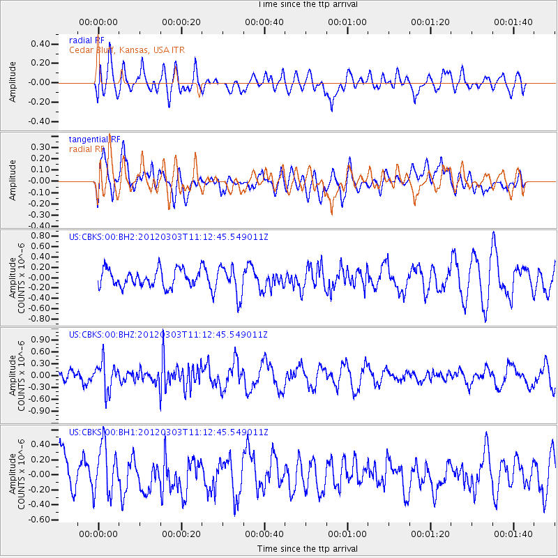
CBKS Cedar Bluff, Kansas, USA - Earthquake Result Viewer
*The percent match for this event was below the threshold and hence no stack was calculated.
| Earthquake location: |
Near Coast Of Central Chile |
| Earthquake latitude/longitude: |
-30.3/-71.1 |
| Earthquake time(UTC): |
2012/03/03 (063) 11:01:47 GMT |
| Earthquake Depth: |
49 km |
| Earthquake Magnitude: |
5.5 MB |
| Earthquake Catalog/Contributor: |
NEIC PDE/NEIC PDE-M |
|
| Network: |
US United States National Seismic Network |
| Station: |
CBKS Cedar Bluff, Kansas, USA |
| Lat/Lon: |
38.81 N/99.74 W |
| Elevation: |
677 m |
|
| Distance: |
73.8 deg |
| Az: |
337.074 deg |
| Baz: |
154.466 deg |
| Ray Param: |
$rayparam |
*The percent match for this event was below the threshold and hence was not used in the summary stack. |
|
| Radial Match: |
43.67093 % |
| Radial Bump: |
400 |
| Transverse Match: |
57.075985 % |
| Transverse Bump: |
400 |
| SOD ConfigId: |
558545 |
| Insert Time: |
2013-09-19 12:52:05.649 +0000 |
| GWidth: |
2.5 |
| Max Bumps: |
400 |
| Tol: |
0.001 |
|
Signal To Noise
| Channel | StoN | STA | LTA |
| US:CBKS:00:BHZ:20120303T11:12:45.549011Z | 2.6252265 | 3.657208E-7 | 1.3931019E-7 |
| US:CBKS:00:BH1:20120303T11:12:45.549011Z | 1.1362675 | 3.326989E-7 | 2.9279977E-7 |
| US:CBKS:00:BH2:20120303T11:12:45.549011Z | 1.8194988 | 2.9656462E-7 | 1.6299248E-7 |
| Arrivals |
| Ps | |
| PpPs | |
| PsPs/PpSs | |


