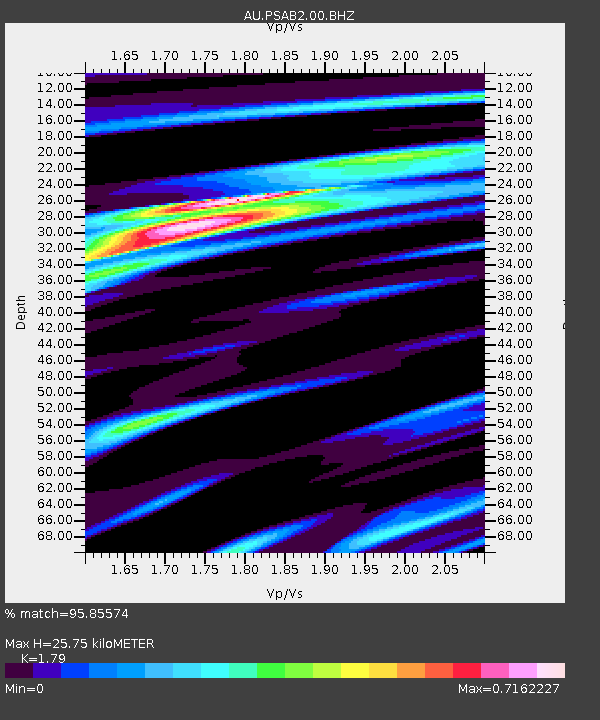
PSAB2 Pilbara Seismic Array Element B2 - Earthquake Result Viewer

Earthquake location: Southeast Of Loyalty Islands
Earthquake latitude/longitude: -22.1/170.3
Earthquake time(UTC): 2012/03/03 (063) 12:19:55 GMT
Earthquake Depth: 14 km
Earthquake Magnitude: 6.5 MB, 6.4 MS, 6.6 MW, 6.6 MW
Earthquake Catalog/Contributor: WHDF/NEIC
Network: AU Australian Seismological Centre
Station: PSAB2 Pilbara Seismic Array Element B2
Lat/Lon: 21.55 S/119.86 E
Elevation: 302 m
Distance: 46.7 deg
Az: 260.772 deg
Baz: 100.56 deg
Ray Param: 0.07048547
Estimated Moho Depth: 25.75 km
Estimated Crust Vp/Vs: 1.79
Assumed Crust Vp: 6.464 km/s
Estimated Crust Vs: 3.611 km/s
Estimated Crust Poisson's Ratio: 0.27
Radial Match: 95.85574 %
Radial Bump: 318
Transverse Match: 72.612656 %
Transverse Bump: 400
SOD ConfigId: 558545
Insert Time: 2013-09-19 12:54:30.007 +0000
GWidth: 2.5
Max Bumps: 400
Tol: 0.001

Signal To Noise

ChannelStoNSTALTA
AU:PSAB2:00:BHZ:20120303T12:27:52.243992Z11.1124881.8974358E-61.7074808E-7
AU:PSAB2:00:BH1:20120303T12:27:52.243992Z4.76166066.4872336E-71.362389E-7
AU:PSAB2:00:BH2:20120303T12:27:52.243992Z4.8303589.0953574E-71.882957E-7
Arrivals
Ps3.3 SECOND
PpPs10 SECOND
PsPs/PpSs14 SECOND