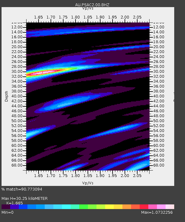
PSAC2 Pilbara Seismic Array Element C2 - Earthquake Result Viewer

Earthquake location: Southeast Of Loyalty Islands
Earthquake latitude/longitude: -22.1/170.3
Earthquake time(UTC): 2012/03/03 (063) 12:19:55 GMT
Earthquake Depth: 14 km
Earthquake Magnitude: 6.5 MB, 6.4 MS, 6.6 MW, 6.6 MW
Earthquake Catalog/Contributor: WHDF/NEIC
Network: AU Australian Seismological Centre
Station: PSAC2 Pilbara Seismic Array Element C2
Lat/Lon: 21.56 S/119.90 E
Elevation: 330 m
Distance: 46.6 deg
Az: 260.771 deg
Baz: 100.545 deg
Ray Param: 0.070508786
Estimated Moho Depth: 30.25 km
Estimated Crust Vp/Vs: 1.66
Assumed Crust Vp: 6.464 km/s
Estimated Crust Vs: 3.882 km/s
Estimated Crust Poisson's Ratio: 0.22
Radial Match: 90.773094 %
Radial Bump: 400
Transverse Match: 75.614174 %
Transverse Bump: 400
SOD ConfigId: 558545
Insert Time: 2013-09-19 12:54:39.867 +0000
GWidth: 2.5
Max Bumps: 400
Tol: 0.001

Signal To Noise

ChannelStoNSTALTA
AU:PSAC2:00:BHZ:20120303T12:27:51.968998Z2.78162531.8066428E-66.4949177E-7
AU:PSAC2:00:BH1:20120303T12:27:51.968998Z6.86119139.680444E-71.4108986E-7
AU:PSAC2:00:BH2:20120303T12:27:51.968998Z3.11069875.289158E-71.7003119E-7
Arrivals
Ps3.3 SECOND
PpPs12 SECOND
PsPs/PpSs15 SECOND