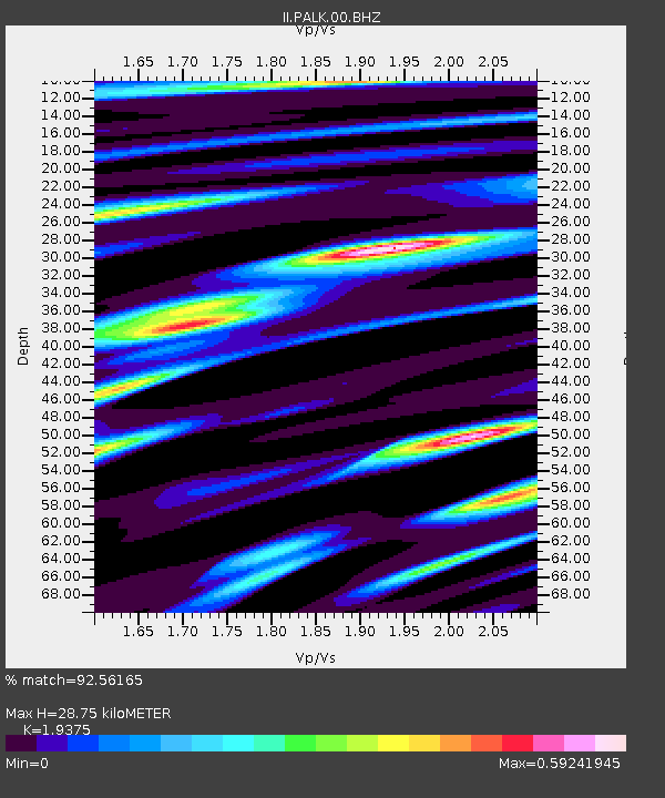
PALK Pallekele, Sri Lanka - Earthquake Result Viewer
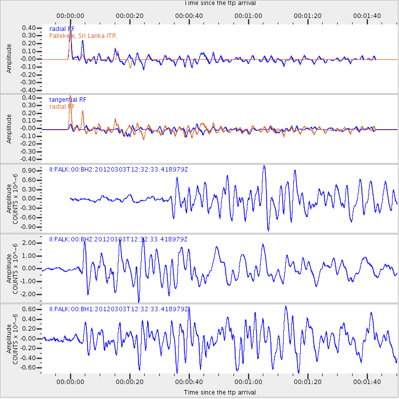
Earthquake location: Southeast Of Loyalty Islands
Earthquake latitude/longitude: -22.1/170.3
Earthquake time(UTC): 2012/03/03 (063) 12:19:55 GMT
Earthquake Depth: 14 km
Earthquake Magnitude: 6.5 MB, 6.4 MS, 6.6 MW, 6.6 MW
Earthquake Catalog/Contributor: WHDF/NEIC
Network: II Global Seismograph Network (GSN - IRIS/IDA)
Station: PALK Pallekele, Sri Lanka
Lat/Lon: 7.27 N/80.70 E
Elevation: 460 m
Distance: 92.4 deg
Az: 276.837 deg
Baz: 111.888 deg
Ray Param: 0.041467484
Estimated Moho Depth: 28.75 km
Estimated Crust Vp/Vs: 1.94
Assumed Crust Vp: 6.545 km/s
Estimated Crust Vs: 3.378 km/s
Estimated Crust Poisson's Ratio: 0.32
Radial Match: 92.56165 %
Radial Bump: 400
Transverse Match: 86.11145 %
Transverse Bump: 400
SOD ConfigId: 558545
Insert Time: 2013-09-19 12:55:18.364 +0000
GWidth: 2.5
Max Bumps: 400
Tol: 0.001

Signal To Noise

ChannelStoNSTALTA
II:PALK:00:BHZ:20120303T12:32:33.418979Z6.95088625.94458E-78.552263E-8
II:PALK:00:BH1:20120303T12:32:33.418979Z1.63852498.0781476E-84.930134E-8
II:PALK:00:BH2:20120303T12:32:33.418979Z2.79448581.5880043E-75.682635E-8
Arrivals
Ps4.2 SECOND
PpPs13 SECOND
PsPs/PpSs17 SECOND