You are here: Home > Network List > IU - Global Seismograph Network (GSN - IRIS/USGS) Stations List
> Station JOHN Johnston Island, USA > Earthquake Result Viewer
JOHN Johnston Island, USA - Earthquake Result Viewer
*The percent match for this event was below the threshold and hence no stack was calculated.
| Earthquake location: |
Southeast Of Loyalty Islands |
| Earthquake latitude/longitude: |
-22.1/170.3 |
| Earthquake time(UTC): |
2012/03/03 (063) 12:19:55 GMT |
| Earthquake Depth: |
14 km |
| Earthquake Magnitude: |
6.5 MB, 6.4 MS, 6.6 MW, 6.6 MW |
| Earthquake Catalog/Contributor: |
WHDF/NEIC |
|
| Network: |
IU Global Seismograph Network (GSN - IRIS/USGS) |
| Station: |
JOHN Johnston Island, USA |
| Lat/Lon: |
16.73 N/169.53 W |
| Elevation: |
2.0 m |
|
| Distance: |
43.4 deg |
| Az: |
28.697 deg |
| Baz: |
207.686 deg |
| Ray Param: |
$rayparam |
*The percent match for this event was below the threshold and hence was not used in the summary stack. |
|
| Radial Match: |
60.047924 % |
| Radial Bump: |
354 |
| Transverse Match: |
61.788506 % |
| Transverse Bump: |
400 |
| SOD ConfigId: |
558545 |
| Insert Time: |
2013-09-19 12:55:42.123 +0000 |
| GWidth: |
2.5 |
| Max Bumps: |
400 |
| Tol: |
0.001 |
|
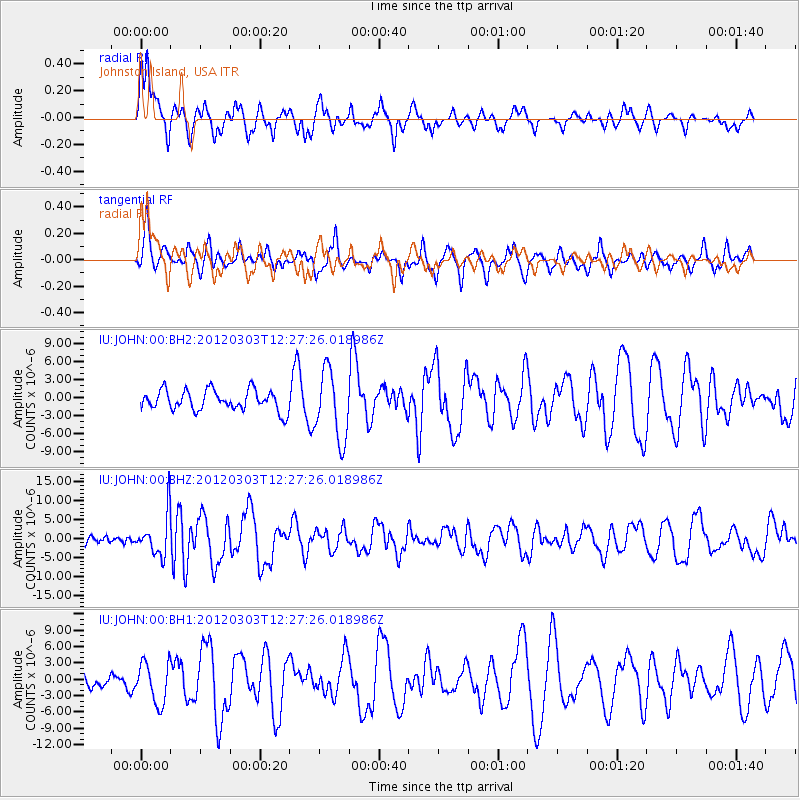
Signal To Noise
| Channel | StoN | STA | LTA |
| IU:JOHN:00:BHZ:20120303T12:27:26.018986Z | 4.4205146 | 5.49897E-6 | 1.2439662E-6 |
| IU:JOHN:00:BH1:20120303T12:27:26.018986Z | 2.3740604 | 3.7659759E-6 | 1.5863017E-6 |
| IU:JOHN:00:BH2:20120303T12:27:26.018986Z | 3.4182527 | 5.7575244E-6 | 1.6843472E-6 |
| Arrivals |
| Ps | |
| PpPs | |
| PsPs/PpSs | |


