You are here: Home > Network List > US - United States National Seismic Network Stations List
> Station TPNV Topopah Spring, Nevada, USA > Earthquake Result Viewer
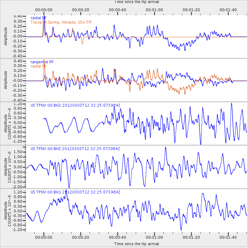
TPNV Topopah Spring, Nevada, USA - Earthquake Result Viewer
*The percent match for this event was below the threshold and hence no stack was calculated.
| Earthquake location: |
Southeast Of Loyalty Islands |
| Earthquake latitude/longitude: |
-22.1/170.3 |
| Earthquake time(UTC): |
2012/03/03 (063) 12:19:55 GMT |
| Earthquake Depth: |
14 km |
| Earthquake Magnitude: |
6.5 MB, 6.4 MS, 6.6 MW, 6.6 MW |
| Earthquake Catalog/Contributor: |
WHDF/NEIC |
|
| Network: |
US United States National Seismic Network |
| Station: |
TPNV Topopah Spring, Nevada, USA |
| Lat/Lon: |
36.95 N/116.25 W |
| Elevation: |
1600 m |
|
| Distance: |
90.7 deg |
| Az: |
50.158 deg |
| Baz: |
242.699 deg |
| Ray Param: |
$rayparam |
*The percent match for this event was below the threshold and hence was not used in the summary stack. |
|
| Radial Match: |
52.48217 % |
| Radial Bump: |
400 |
| Transverse Match: |
48.94576 % |
| Transverse Bump: |
400 |
| SOD ConfigId: |
558545 |
| Insert Time: |
2013-09-19 12:56:25.072 +0000 |
| GWidth: |
2.5 |
| Max Bumps: |
400 |
| Tol: |
0.001 |
|
Signal To Noise
| Channel | StoN | STA | LTA |
| US:TPNV:00:BHZ:20120303T12:32:25.673984Z | 2.0308435 | 3.5531525E-7 | 1.7495944E-7 |
| US:TPNV:00:BH1:20120303T12:32:25.673984Z | 2.2308292 | 5.391398E-7 | 2.4167687E-7 |
| US:TPNV:00:BH2:20120303T12:32:25.673984Z | 0.945562 | 2.8793124E-7 | 3.0450803E-7 |
| Arrivals |
| Ps | |
| PpPs | |
| PsPs/PpSs | |


