You are here: Home > Network List > CN - Canadian National Seismograph Network Stations List
> Station MBC > Earthquake Result Viewer
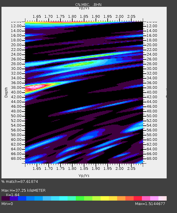
MBC - Earthquake Result Viewer
| Earthquake location: |
Mariana Islands Region |
| Earthquake latitude/longitude: |
21.8/142.6 |
| Earthquake time(UTC): |
1995/04/08 (098) 17:45:18 GMT |
| Earthquake Depth: |
319 km |
| Earthquake Magnitude: |
6.3 MB |
| Earthquake Catalog/Contributor: |
WHDF/NEIC |
|
| Network: |
CN Canadian National Seismograph Network |
| Station: |
MBC |
| Lat/Lon: |
76.24 N/119.36 W |
| Elevation: |
15 m |
|
| Distance: |
70.9 deg |
| Az: |
14.527 deg |
| Baz: |
283.096 deg |
| Ray Param: |
0.05374501 |
| Estimated Moho Depth: |
37.25 km |
| Estimated Crust Vp/Vs: |
1.64 |
| Assumed Crust Vp: |
6.391 km/s |
| Estimated Crust Vs: |
3.897 km/s |
| Estimated Crust Poisson's Ratio: |
0.20 |
|
| Radial Match: |
87.61874 % |
| Radial Bump: |
400 |
| Transverse Match: |
86.67685 % |
| Transverse Bump: |
400 |
| SOD ConfigId: |
4480 |
| Insert Time: |
2010-02-27 06:44:48.860 +0000 |
| GWidth: |
2.5 |
| Max Bumps: |
400 |
| Tol: |
0.001 |
|

Signal To Noise
| Channel | StoN | STA | LTA |
| CN:MBC: :BHN:19950408T17:55:30.024011Z | 0.68999404 | 1.7054286E-6 | 2.4716571E-6 |
| CN:MBC: :BHE:19950408T17:55:30.024011Z | 8.051093 | 1.0531376E-6 | 1.3080678E-7 |
| CN:MBC: :BHZ:19950408T17:55:30.024011Z | 2.2433677 | 1.2225315E-6 | 5.449537E-7 |
| Arrivals |
| Ps | 3.9 SECOND |
| PpPs | 15 SECOND |
| PsPs/PpSs | 19 SECOND |


