You are here: Home > Network List > US - United States National Seismic Network Stations List
> Station MNTX Cornudas Mountains, Texas, USA > Earthquake Result Viewer
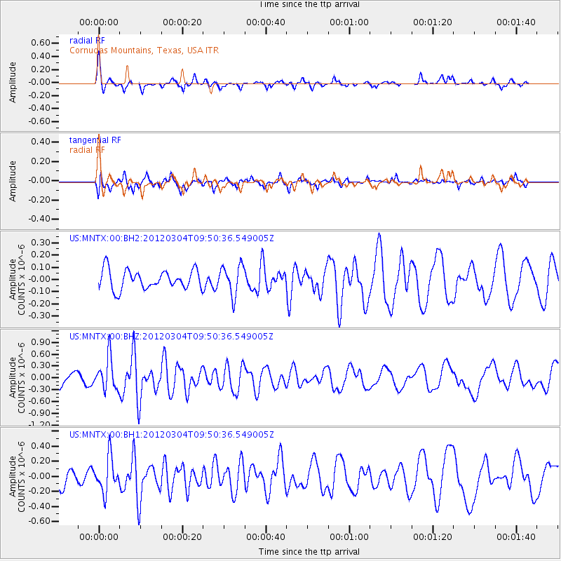
MNTX Cornudas Mountains, Texas, USA - Earthquake Result Viewer
*The percent match for this event was below the threshold and hence no stack was calculated.
| Earthquake location: |
Off Coast Of Central America |
| Earthquake latitude/longitude: |
2.7/-84.3 |
| Earthquake time(UTC): |
2012/03/04 (064) 09:44:14 GMT |
| Earthquake Depth: |
9.0 km |
| Earthquake Magnitude: |
5.5 MB, 5.5 MW |
| Earthquake Catalog/Contributor: |
NEIC PDE/NEIC PDE-M |
|
| Network: |
US United States National Seismic Network |
| Station: |
MNTX Cornudas Mountains, Texas, USA |
| Lat/Lon: |
31.70 N/105.38 W |
| Elevation: |
404 m |
|
| Distance: |
35.0 deg |
| Az: |
327.761 deg |
| Baz: |
141.307 deg |
| Ray Param: |
$rayparam |
*The percent match for this event was below the threshold and hence was not used in the summary stack. |
|
| Radial Match: |
64.10465 % |
| Radial Bump: |
324 |
| Transverse Match: |
48.964355 % |
| Transverse Bump: |
343 |
| SOD ConfigId: |
558545 |
| Insert Time: |
2013-09-19 12:59:48.342 +0000 |
| GWidth: |
2.5 |
| Max Bumps: |
400 |
| Tol: |
0.001 |
|
Signal To Noise
| Channel | StoN | STA | LTA |
| US:MNTX:00:BHZ:20120304T09:50:36.549005Z | 4.194029 | 4.231609E-7 | 1.0089604E-7 |
| US:MNTX:00:BH1:20120304T09:50:36.549005Z | 1.5160639 | 2.3563689E-7 | 1.5542676E-7 |
| US:MNTX:00:BH2:20120304T09:50:36.549005Z | 1.6076158 | 1.2541216E-7 | 7.8011276E-8 |
| Arrivals |
| Ps | |
| PpPs | |
| PsPs/PpSs | |


