You are here: Home > Network List > US - United States National Seismic Network Stations List
> Station WMOK Wichita Mountains, Oklahoma, USA > Earthquake Result Viewer
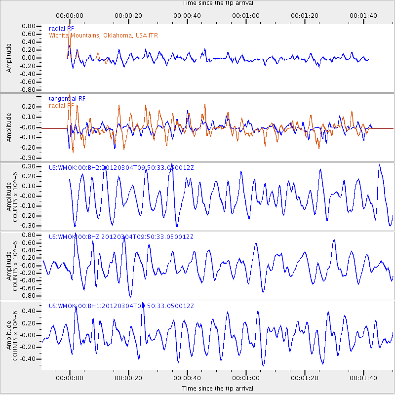
WMOK Wichita Mountains, Oklahoma, USA - Earthquake Result Viewer
*The percent match for this event was below the threshold and hence no stack was calculated.
| Earthquake location: |
Off Coast Of Central America |
| Earthquake latitude/longitude: |
2.7/-84.3 |
| Earthquake time(UTC): |
2012/03/04 (064) 09:44:14 GMT |
| Earthquake Depth: |
9.0 km |
| Earthquake Magnitude: |
5.5 MB, 5.5 MW |
| Earthquake Catalog/Contributor: |
NEIC PDE/NEIC PDE-M |
|
| Network: |
US United States National Seismic Network |
| Station: |
WMOK Wichita Mountains, Oklahoma, USA |
| Lat/Lon: |
34.74 N/98.78 W |
| Elevation: |
486 m |
|
| Distance: |
34.6 deg |
| Az: |
338.799 deg |
| Baz: |
153.983 deg |
| Ray Param: |
$rayparam |
*The percent match for this event was below the threshold and hence was not used in the summary stack. |
|
| Radial Match: |
62.795956 % |
| Radial Bump: |
400 |
| Transverse Match: |
48.609863 % |
| Transverse Bump: |
400 |
| SOD ConfigId: |
558545 |
| Insert Time: |
2013-09-19 13:00:25.543 +0000 |
| GWidth: |
2.5 |
| Max Bumps: |
400 |
| Tol: |
0.001 |
|
Signal To Noise
| Channel | StoN | STA | LTA |
| US:WMOK:00:BHZ:20120304T09:50:33.050012Z | 4.682246 | 4.0644144E-7 | 8.68048E-8 |
| US:WMOK:00:BH1:20120304T09:50:33.050012Z | 1.8705934 | 2.4512846E-7 | 1.3104317E-7 |
| US:WMOK:00:BH2:20120304T09:50:33.050012Z | 1.0453026 | 1.5991786E-7 | 1.5298714E-7 |
| Arrivals |
| Ps | |
| PpPs | |
| PsPs/PpSs | |


