You are here: Home > Network List > US - United States National Seismic Network Stations List
> Station AGMN Agassiz National Wildlife Refuge, Minnesota, USA > Earthquake Result Viewer
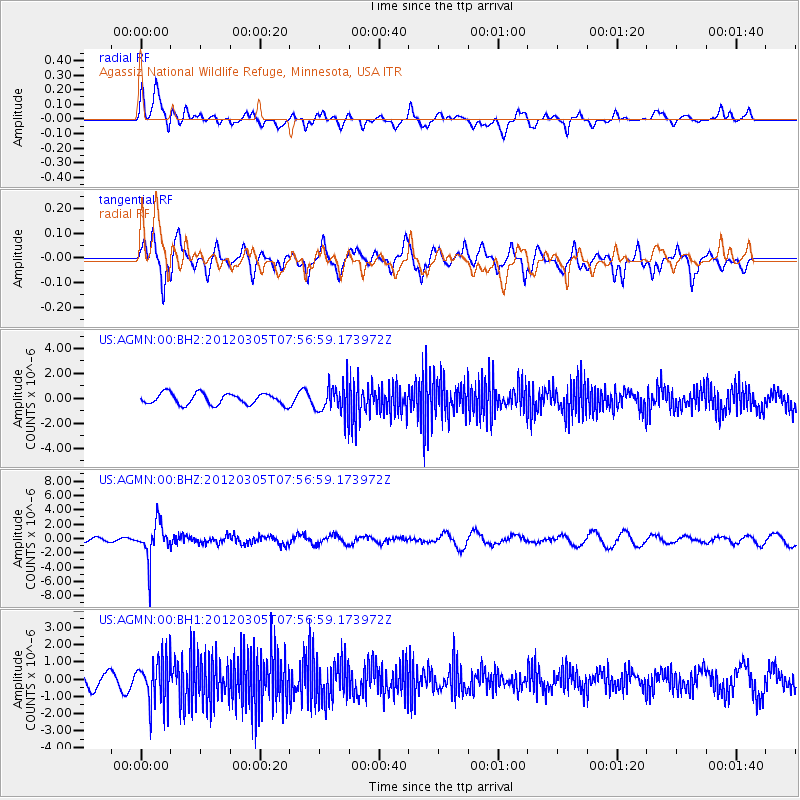
AGMN Agassiz National Wildlife Refuge, Minnesota, USA - Earthquake Result Viewer
*The percent match for this event was below the threshold and hence no stack was calculated.
| Earthquake location: |
Santiago Del Estero Prov., Arg. |
| Earthquake latitude/longitude: |
-28.2/-63.3 |
| Earthquake time(UTC): |
2012/03/05 (065) 07:46:10 GMT |
| Earthquake Depth: |
554 km |
| Earthquake Magnitude: |
6.0 MB, 6.1 MW, 6.1 MW |
| Earthquake Catalog/Contributor: |
WHDF/NEIC |
|
| Network: |
US United States National Seismic Network |
| Station: |
AGMN Agassiz National Wildlife Refuge, Minnesota, USA |
| Lat/Lon: |
48.30 N/95.86 W |
| Elevation: |
351 m |
|
| Distance: |
81.6 deg |
| Az: |
338.694 deg |
| Baz: |
151.311 deg |
| Ray Param: |
$rayparam |
*The percent match for this event was below the threshold and hence was not used in the summary stack. |
|
| Radial Match: |
47.497185 % |
| Radial Bump: |
400 |
| Transverse Match: |
69.83695 % |
| Transverse Bump: |
379 |
| SOD ConfigId: |
558545 |
| Insert Time: |
2013-09-19 13:07:57.799 +0000 |
| GWidth: |
2.5 |
| Max Bumps: |
400 |
| Tol: |
0.001 |
|
Signal To Noise
| Channel | StoN | STA | LTA |
| US:AGMN:00:BHZ:20120305T07:56:59.173972Z | 5.902982 | 2.5475904E-6 | 4.3157686E-7 |
| US:AGMN:00:BH1:20120305T07:56:59.173972Z | 2.7429643 | 1.3525186E-6 | 4.930865E-7 |
| US:AGMN:00:BH2:20120305T07:56:59.173972Z | 2.6044607 | 1.169461E-6 | 4.490223E-7 |
| Arrivals |
| Ps | |
| PpPs | |
| PsPs/PpSs | |


