You are here: Home > Network List > US - United States National Seismic Network Stations List
> Station AMTX Amarillo, Texas, USA > Earthquake Result Viewer
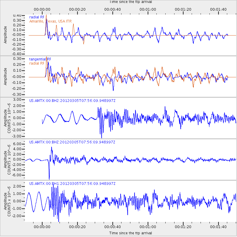
AMTX Amarillo, Texas, USA - Earthquake Result Viewer
*The percent match for this event was below the threshold and hence no stack was calculated.
| Earthquake location: |
Santiago Del Estero Prov., Arg. |
| Earthquake latitude/longitude: |
-28.2/-63.3 |
| Earthquake time(UTC): |
2012/03/05 (065) 07:46:10 GMT |
| Earthquake Depth: |
554 km |
| Earthquake Magnitude: |
6.0 MB, 6.1 MW, 6.1 MW |
| Earthquake Catalog/Contributor: |
WHDF/NEIC |
|
| Network: |
US United States National Seismic Network |
| Station: |
AMTX Amarillo, Texas, USA |
| Lat/Lon: |
34.53 N/101.41 W |
| Elevation: |
1010 m |
|
| Distance: |
72.1 deg |
| Az: |
327.621 deg |
| Baz: |
145.092 deg |
| Ray Param: |
$rayparam |
*The percent match for this event was below the threshold and hence was not used in the summary stack. |
|
| Radial Match: |
42.898308 % |
| Radial Bump: |
400 |
| Transverse Match: |
55.78094 % |
| Transverse Bump: |
400 |
| SOD ConfigId: |
558545 |
| Insert Time: |
2013-09-19 13:07:59.027 +0000 |
| GWidth: |
2.5 |
| Max Bumps: |
400 |
| Tol: |
0.001 |
|
Signal To Noise
| Channel | StoN | STA | LTA |
| US:AMTX:00:BHZ:20120305T07:56:09.948997Z | 3.3471906 | 1.7512025E-6 | 5.231858E-7 |
| US:AMTX:00:BH1:20120305T07:56:09.948997Z | 1.3118366 | 7.376384E-7 | 5.622944E-7 |
| US:AMTX:00:BH2:20120305T07:56:09.948997Z | 0.96713275 | 5.180425E-7 | 5.356478E-7 |
| Arrivals |
| Ps | |
| PpPs | |
| PsPs/PpSs | |


