You are here: Home > Network List > US - United States National Seismic Network Stations List
> Station ERPA Erie, Pennsylvania, USA > Earthquake Result Viewer
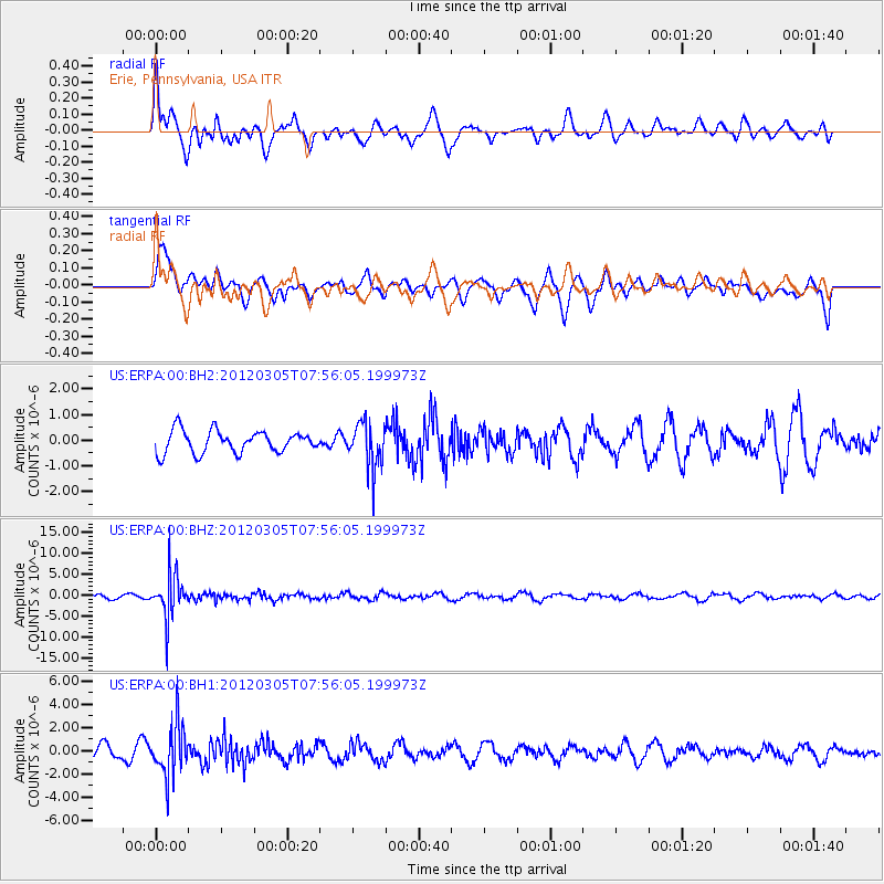
ERPA Erie, Pennsylvania, USA - Earthquake Result Viewer
*The percent match for this event was below the threshold and hence no stack was calculated.
| Earthquake location: |
Santiago Del Estero Prov., Arg. |
| Earthquake latitude/longitude: |
-28.2/-63.3 |
| Earthquake time(UTC): |
2012/03/05 (065) 07:46:10 GMT |
| Earthquake Depth: |
554 km |
| Earthquake Magnitude: |
6.0 MB, 6.1 MW, 6.1 MW |
| Earthquake Catalog/Contributor: |
WHDF/NEIC |
|
| Network: |
US United States National Seismic Network |
| Station: |
ERPA Erie, Pennsylvania, USA |
| Lat/Lon: |
42.12 N/79.99 W |
| Elevation: |
306 m |
|
| Distance: |
71.7 deg |
| Az: |
346.989 deg |
| Baz: |
164.516 deg |
| Ray Param: |
$rayparam |
*The percent match for this event was below the threshold and hence was not used in the summary stack. |
|
| Radial Match: |
47.69771 % |
| Radial Bump: |
400 |
| Transverse Match: |
52.30892 % |
| Transverse Bump: |
400 |
| SOD ConfigId: |
558545 |
| Insert Time: |
2013-09-19 13:08:41.571 +0000 |
| GWidth: |
2.5 |
| Max Bumps: |
400 |
| Tol: |
0.001 |
|
Signal To Noise
| Channel | StoN | STA | LTA |
| US:ERPA:00:BHZ:20120305T07:56:05.199973Z | 10.418028 | 5.165682E-6 | 4.958407E-7 |
| US:ERPA:00:BH1:20120305T07:56:05.199973Z | 4.076819 | 2.1343178E-6 | 5.235253E-7 |
| US:ERPA:00:BH2:20120305T07:56:05.199973Z | 1.9919715 | 8.520898E-7 | 4.2776205E-7 |
| Arrivals |
| Ps | |
| PpPs | |
| PsPs/PpSs | |


