You are here: Home > Network List > CN - Canadian National Seismograph Network Stations List
> Station MBC Mould Bay, Northwest Territories, Canada > Earthquake Result Viewer
MBC Mould Bay, Northwest Territories, Canada - Earthquake Result Viewer
| Earthquake location: |
Peru-Ecuador Border Region |
| Earthquake latitude/longitude: |
-2.8/-77.9 |
| Earthquake time(UTC): |
1995/10/03 (276) 01:51:24 GMT |
| Earthquake Depth: |
27 km |
| Earthquake Magnitude: |
6.5 MB, 7.0 MS, 6.9 UNKNOWN, 7.0 MW |
| Earthquake Catalog/Contributor: |
WHDF/NEIC |
|
| Network: |
CN Canadian National Seismograph Network |
| Station: |
MBC Mould Bay, Northwest Territories, Canada |
| Lat/Lon: |
76.24 N/119.36 W |
| Elevation: |
15 m |
|
| Distance: |
82.4 deg |
| Az: |
350.798 deg |
| Baz: |
138.132 deg |
| Ray Param: |
0.046889048 |
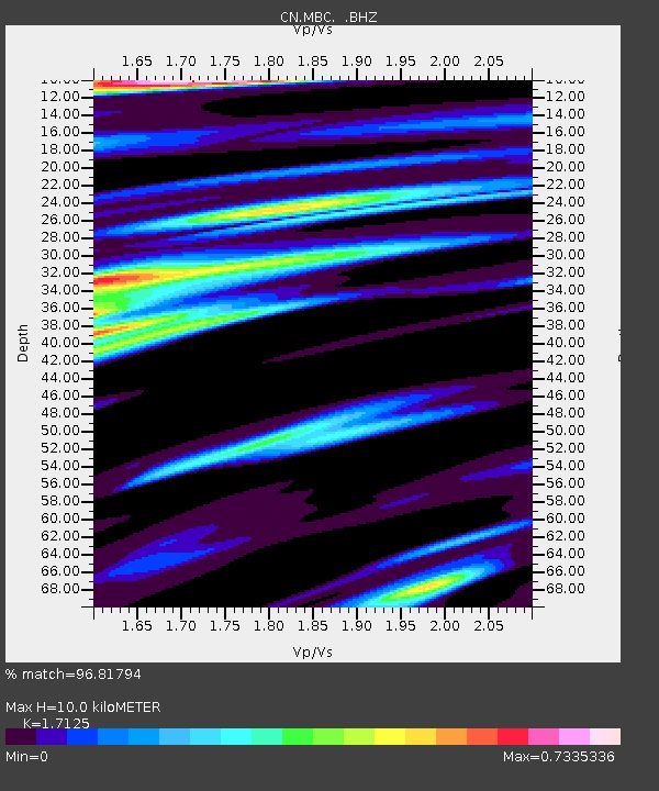
| Estimated Moho Depth: |
10.0 km |
| Estimated Crust Vp/Vs: |
1.71 |
| Assumed Crust Vp: |
6.391 km/s |
| Estimated Crust Vs: |
3.732 km/s |
| Estimated Crust Poisson's Ratio: |
0.24 |
|
| Radial Match: |
96.81794 % |
| Radial Bump: |
400 |
| Transverse Match: |
92.58102 % |
| Transverse Bump: |
400 |
| SOD ConfigId: |
4480 |
| Insert Time: |
2010-02-27 06:46:20.207 +0000 |
| GWidth: |
2.5 |
| Max Bumps: |
400 |
| Tol: |
0.001 |
|

Signal To Noise
| Channel | StoN | STA | LTA |
| CN:MBC: :BHZ:19951003T02:03:12.344995Z | 15.224117 | 7.942995E-6 | 5.217376E-7 |
| CN:MBC: :BHN:19951003T02:03:12.344995Z | 5.8519235 | 1.8126932E-6 | 3.0976022E-7 |
| CN:MBC: :BHE:19951003T02:03:12.344995Z | 6.5038815 | 1.4186537E-6 | 2.1812416E-7 |
| Arrivals |
| Ps | 1.1 SECOND |
| PpPs | 4.1 SECOND |
| PsPs/PpSs | 5.3 SECOND |


