You are here: Home > Network List > CN - Canadian National Seismograph Network Stations List
> Station MBC Mould Bay, Northwest Territories, Canada > Earthquake Result Viewer
MBC Mould Bay, Northwest Territories, Canada - Earthquake Result Viewer
| Earthquake location: |
Peru-Ecuador Border Region |
| Earthquake latitude/longitude: |
-2.8/-77.9 |
| Earthquake time(UTC): |
1995/10/03 (276) 12:45:00 GMT |
| Earthquake Depth: |
33 km |
| Earthquake Magnitude: |
6.0 MB, 6.1 MS, 5.9 UNKNOWN, 6.4 MW |
| Earthquake Catalog/Contributor: |
WHDF/NEIC |
|
| Network: |
CN Canadian National Seismograph Network |
| Station: |
MBC Mould Bay, Northwest Territories, Canada |
| Lat/Lon: |
76.24 N/119.36 W |
| Elevation: |
15 m |
|
| Distance: |
82.4 deg |
| Az: |
350.801 deg |
| Baz: |
138.151 deg |
| Ray Param: |
0.046849895 |
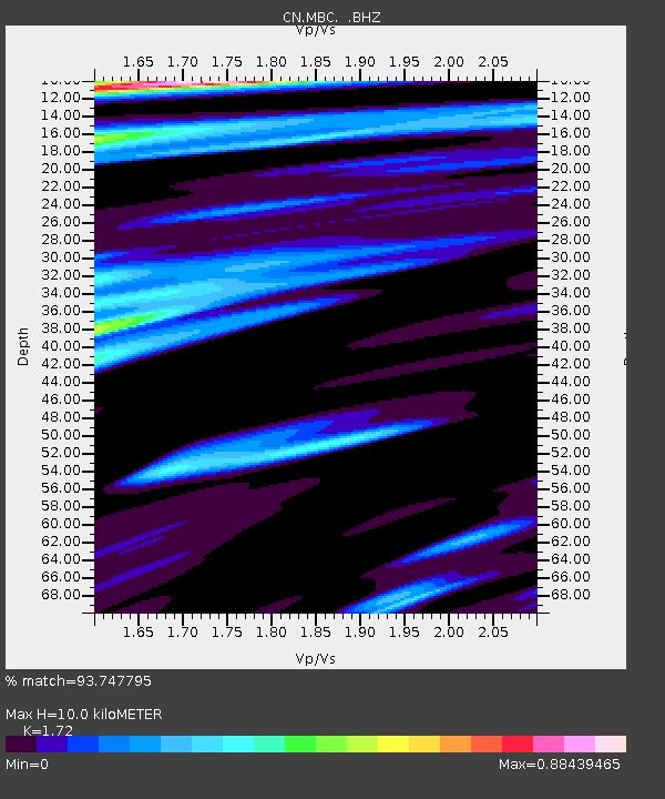
| Estimated Moho Depth: |
10.0 km |
| Estimated Crust Vp/Vs: |
1.72 |
| Assumed Crust Vp: |
6.391 km/s |
| Estimated Crust Vs: |
3.715 km/s |
| Estimated Crust Poisson's Ratio: |
0.24 |
|
| Radial Match: |
93.747795 % |
| Radial Bump: |
400 |
| Transverse Match: |
85.36482 % |
| Transverse Bump: |
400 |
| SOD ConfigId: |
4480 |
| Insert Time: |
2010-02-27 06:46:24.099 +0000 |
| GWidth: |
2.5 |
| Max Bumps: |
400 |
| Tol: |
0.001 |
|

Signal To Noise
| Channel | StoN | STA | LTA |
| CN:MBC: :BHZ:19951003T12:56:47.844995Z | 13.914711 | 2.9263729E-6 | 2.1030785E-7 |
| CN:MBC: :BHN:19951003T12:56:47.844995Z | 6.3018403 | 7.549661E-7 | 1.1980089E-7 |
| CN:MBC: :BHE:19951003T12:56:47.844995Z | 10.220445 | 7.099543E-7 | 6.946413E-8 |
| Arrivals |
| Ps | 1.2 SECOND |
| PpPs | 4.1 SECOND |
| PsPs/PpSs | 5.3 SECOND |


