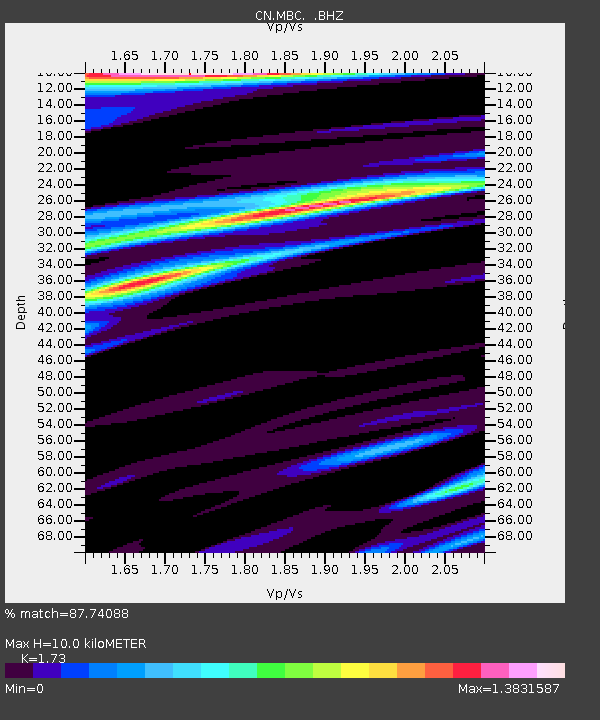
MBC Mould Bay, Northwest Territories, Canada - Earthquake Result Viewer

Earthquake location: Near East Coast Of Honshu, Japan
Earthquake latitude/longitude: 35.5/140.9
Earthquake time(UTC): 1996/09/11 (255) 02:37:14 GMT
Earthquake Depth: 55 km
Earthquake Magnitude: 6.1 MB, 5.7 MS, 6.2 UNKNOWN, 6.1 MW
Earthquake Catalog/Contributor: WHDF/NEIC
Network: CN Canadian National Seismograph Network
Station: MBC Mould Bay, Northwest Territories, Canada
Lat/Lon: 76.24 N/119.36 W
Elevation: 15 m
Distance: 58.1 deg
Az: 16.14 deg
Baz: 288.685 deg
Ray Param: 0.062954254
Estimated Moho Depth: 10.0 km
Estimated Crust Vp/Vs: 1.73
Assumed Crust Vp: 6.391 km/s
Estimated Crust Vs: 3.694 km/s
Estimated Crust Poisson's Ratio: 0.25
Radial Match: 87.74088 %
Radial Bump: 400
Transverse Match: 77.26529 %
Transverse Bump: 400
SOD ConfigId: 4480
Insert Time: 2010-02-27 06:46:35.243 +0000
GWidth: 2.5
Max Bumps: 400
Tol: 0.001

Signal To Noise

ChannelStoNSTALTA
CN:MBC: :BHZ:19960911T02:46:31.775Z14.7611811.3002544E-68.8086075E-8
CN:MBC: :BHN:19960911T02:46:31.775Z1.96710991.09573335E-75.57027E-8
CN:MBC: :BHE:19960911T02:46:31.775Z4.70571853.669115E-77.797141E-8
Arrivals
Ps1.2 SECOND
PpPs4.1 SECOND
PsPs/PpSs5.3 SECOND