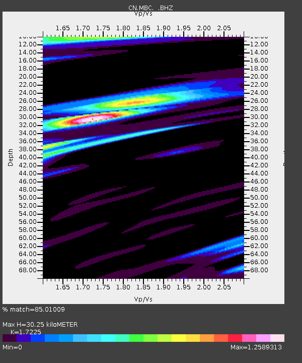
MBC Mould Bay, Northwest Territories, Canada - Earthquake Result Viewer

Earthquake location: Off East Coast Of Honshu, Japan
Earthquake latitude/longitude: 40.8/143.4
Earthquake time(UTC): 1995/12/30 (364) 12:11:07 GMT
Earthquake Depth: 33 km
Earthquake Magnitude: 5.7 MB, 6.2 MS, 6.4 UNKNOWN, 6.3 MW
Earthquake Catalog/Contributor: WHDF/NEIC
Network: CN Canadian National Seismograph Network
Station: MBC Mould Bay, Northwest Territories, Canada
Lat/Lon: 76.24 N/119.36 W
Elevation: 15 m
Distance: 52.5 deg
Az: 17.416 deg
Baz: 288.286 deg
Ray Param: 0.06666559
Estimated Moho Depth: 30.25 km
Estimated Crust Vp/Vs: 1.72
Assumed Crust Vp: 6.391 km/s
Estimated Crust Vs: 3.71 km/s
Estimated Crust Poisson's Ratio: 0.25
Radial Match: 85.01009 %
Radial Bump: 400
Transverse Match: 64.041756 %
Transverse Bump: 400
SOD ConfigId: 4480
Insert Time: 2010-02-27 06:46:50.669 +0000
GWidth: 2.5
Max Bumps: 400
Tol: 0.001

Signal To Noise

ChannelStoNSTALTA
CN:MBC: :BHZ:19951230T12:19:46.525Z5.0971581.7578045E-63.4485973E-7
CN:MBC: :BHN:19951230T12:19:46.525Z0.949731773.249642E-73.4216418E-7
CN:MBC: :BHE:19951230T12:19:46.525Z2.60309845.044786E-71.9379928E-7
Arrivals
Ps3.6 SECOND
PpPs12 SECOND
PsPs/PpSs16 SECOND