You are here: Home > Network List > US - United States National Seismic Network Stations List
> Station EGMT Eagleton, Montana, USA > Earthquake Result Viewer
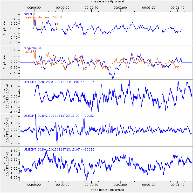
EGMT Eagleton, Montana, USA - Earthquake Result Viewer
*The percent match for this event was below the threshold and hence no stack was calculated.
| Earthquake location: |
Near Coast Of Chiapas, Mexico |
| Earthquake latitude/longitude: |
15.0/-93.0 |
| Earthquake time(UTC): |
2012/03/13 (073) 23:06:43 GMT |
| Earthquake Depth: |
49 km |
| Earthquake Magnitude: |
5.5 MW, 5.5 MW, 5.5 MB |
| Earthquake Catalog/Contributor: |
NEIC PDE/NEIC PDE-M |
|
| Network: |
US United States National Seismic Network |
| Station: |
EGMT Eagleton, Montana, USA |
| Lat/Lon: |
48.02 N/109.75 W |
| Elevation: |
1055 m |
|
| Distance: |
35.8 deg |
| Az: |
340.691 deg |
| Baz: |
151.569 deg |
| Ray Param: |
$rayparam |
*The percent match for this event was below the threshold and hence was not used in the summary stack. |
|
| Radial Match: |
44.09427 % |
| Radial Bump: |
400 |
| Transverse Match: |
22.734602 % |
| Transverse Bump: |
400 |
| SOD ConfigId: |
558545 |
| Insert Time: |
2013-09-19 13:37:14.210 +0000 |
| GWidth: |
2.5 |
| Max Bumps: |
400 |
| Tol: |
0.001 |
|
Signal To Noise
| Channel | StoN | STA | LTA |
| US:EGMT:00:BHZ:20120313T23:13:07.449008Z | 3.215085 | 8.7933444E-7 | 2.735027E-7 |
| US:EGMT:00:BH1:20120313T23:13:07.449008Z | 0.64297986 | 3.061572E-7 | 4.7615362E-7 |
| US:EGMT:00:BH2:20120313T23:13:07.449008Z | 0.80097985 | 3.089506E-7 | 3.857158E-7 |
| Arrivals |
| Ps | |
| PpPs | |
| PsPs/PpSs | |


