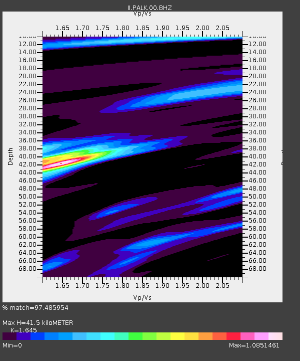
PALK Pallekele, Sri Lanka - Earthquake Result Viewer
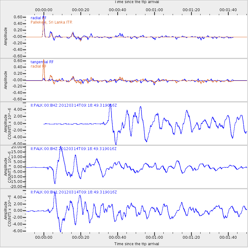
Earthquake location: Off East Coast Of Honshu, Japan
Earthquake latitude/longitude: 40.9/144.9
Earthquake time(UTC): 2012/03/14 (074) 09:08:35 GMT
Earthquake Depth: 12 km
Earthquake Magnitude: 6.7 MB, 6.9 MS, 6.9 MW, 7.0 MW
Earthquake Catalog/Contributor: WHDF/NEIC
Network: II Global Seismograph Network (GSN - IRIS/IDA)
Station: PALK Pallekele, Sri Lanka
Lat/Lon: 7.27 N/80.70 E
Elevation: 460 m
Distance: 65.9 deg
Az: 258.255 deg
Baz: 48.438 deg
Ray Param: 0.057986397
Estimated Moho Depth: 41.5 km
Estimated Crust Vp/Vs: 1.64
Assumed Crust Vp: 6.545 km/s
Estimated Crust Vs: 3.979 km/s
Estimated Crust Poisson's Ratio: 0.21
Radial Match: 97.485954 %
Radial Bump: 300
Transverse Match: 92.34971 %
Transverse Bump: 400
SOD ConfigId: 558545
Insert Time: 2013-09-19 13:39:33.746 +0000
GWidth: 2.5
Max Bumps: 400
Tol: 0.001

Signal To Noise

ChannelStoNSTALTA
II:PALK:00:BHZ:20120314T09:18:49.319016Z9.1815727.743037E-78.433236E-8
II:PALK:00:BH1:20120314T09:18:49.319016Z3.49310562.72104E-77.789745E-8
II:PALK:00:BH2:20120314T09:18:49.319016Z4.1072982.753675E-76.704347E-8
Arrivals
Ps4.3 SECOND
PpPs16 SECOND
PsPs/PpSs20 SECOND