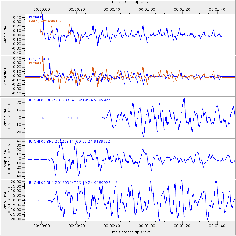
GNI Garni, Armenia - Earthquake Result Viewer
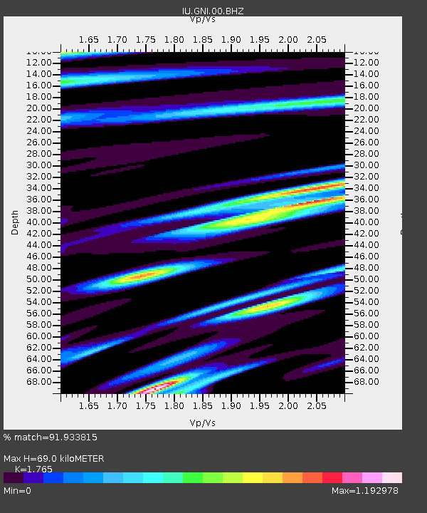
Earthquake location: Off East Coast Of Honshu, Japan
Earthquake latitude/longitude: 40.9/144.9
Earthquake time(UTC): 2012/03/14 (074) 09:08:35 GMT
Earthquake Depth: 12 km
Earthquake Magnitude: 6.7 MB, 6.9 MS, 6.9 MW, 7.0 MW
Earthquake Catalog/Contributor: WHDF/NEIC
Network: IU Global Seismograph Network (GSN - IRIS/USGS)
Station: GNI Garni, Armenia
Lat/Lon: 40.15 N/44.74 E
Elevation: 1609 m
Distance: 71.6 deg
Az: 307.337 deg
Baz: 51.854 deg
Ray Param: 0.054223225
Estimated Moho Depth: 69.0 km
Estimated Crust Vp/Vs: 1.76
Assumed Crust Vp: 6.291 km/s
Estimated Crust Vs: 3.564 km/s
Estimated Crust Poisson's Ratio: 0.26
Radial Match: 91.933815 %
Radial Bump: 400
Transverse Match: 91.121574 %
Transverse Bump: 400
SOD ConfigId: 558545
Insert Time: 2013-09-19 13:39:57.894 +0000
GWidth: 2.5
Max Bumps: 400
Tol: 0.001

Signal To Noise

ChannelStoNSTALTA
IU:GNI:00:BHZ:20120314T09:19:24.918992Z13.4486571.0623226E-67.899098E-8
IU:GNI:00:BH1:20120314T09:19:24.918992Z1.6307282.0004785E-71.2267395E-7
IU:GNI:00:BH2:20120314T09:19:24.918992Z2.23652152.5396568E-71.1355387E-7
Arrivals
Ps8.7 SECOND
PpPs29 SECOND
PsPs/PpSs38 SECOND