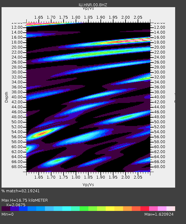
HNR Honiara, Solomon Islands - Earthquake Result Viewer
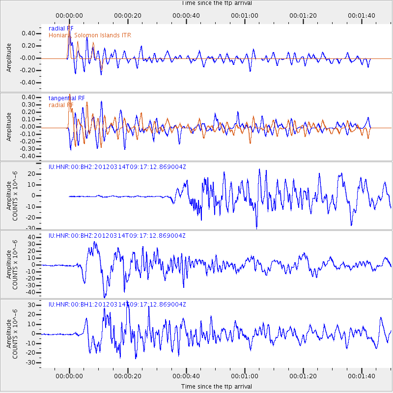
Earthquake location: Off East Coast Of Honshu, Japan
Earthquake latitude/longitude: 40.9/144.9
Earthquake time(UTC): 2012/03/14 (074) 09:08:35 GMT
Earthquake Depth: 12 km
Earthquake Magnitude: 6.7 MB, 6.9 MS, 6.9 MW, 7.0 MW
Earthquake Catalog/Contributor: WHDF/NEIC
Network: IU Global Seismograph Network (GSN - IRIS/USGS)
Station: HNR Honiara, Solomon Islands
Lat/Lon: 9.44 S/159.95 E
Elevation: 100 m
Distance: 52.0 deg
Az: 161.074 deg
Baz: 345.568 deg
Ray Param: 0.06706903
Estimated Moho Depth: 16.75 km
Estimated Crust Vp/Vs: 2.07
Assumed Crust Vp: 6.183 km/s
Estimated Crust Vs: 2.99 km/s
Estimated Crust Poisson's Ratio: 0.35
Radial Match: 82.19241 %
Radial Bump: 400
Transverse Match: 82.68956 %
Transverse Bump: 400
SOD ConfigId: 558545
Insert Time: 2013-09-19 13:39:59.060 +0000
GWidth: 2.5
Max Bumps: 400
Tol: 0.001

Signal To Noise

ChannelStoNSTALTA
IU:HNR:00:BHZ:20120314T09:17:12.869004Z15.0475795.216296E-63.466535E-7
IU:HNR:00:BH1:20120314T09:17:12.869004Z2.42748177.4933723E-73.0868915E-7
IU:HNR:00:BH2:20120314T09:17:12.869004Z1.74655075.6421703E-73.230465E-7
Arrivals
Ps3.0 SECOND
PpPs8.0 SECOND
PsPs/PpSs11 SECOND